


Dutch design firm West 8 recently won a competition to rethink an 11-mile stretch of the Baltimore's waterfront, not to be confused with a $5.5 billion project to redevelop Port Covington.
Ethan McLeod reports for Next City on the recently revealed designs to remake the Baltimore waterfront along the Middle Branch of the Patapsco River, a relatively calm stretch of water that feeds into the busier Inner harbor.
The city held a design competition to rethink the area, focusing around Hanover Street Bridge, doomed for removal as it reaches the end of its 103-year lifespan. The city announced Dutch design company West 8 as the winner in July 2019. McLeod provided news coverage as the design competition neared culmination for Baltimore Fishbowl.
The West 8 design "reimagines the Middle Branch as a 'blue green heart' for Baltimore, with an 11-mile loop connecting the shorelines of Westport, Cherry Hill, Riverside, Brooklyn and Port Covington," according to McLeod, in the more recent of the two articles.
"West 8 hopes to upcycle dredged material from the nearby Port of Baltimore as the base for the new marshes and greenery at the water’s edge, similarly to how the firm’s home country of Holland designed new infrastructure like dikes and bridges," according to McLeod. "The design eyes major re-uses as well, like converting an abandoned swing bridge into a pedestrian walkway and fashioning a linear park out of the 103-year-old Hanover Street Bridge."
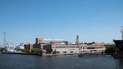
The Hanover Street Bridge provides commuter access to Port Covington, site of a proposed mega-development spearheaded by Under Armour CEO Kevin Plank and aided by fortuitous mapping of the city's new federal Opportunity Zones. West 8 proposes building a new bridge, to replace the crumbling Hanover Street Bridge, farther down river.
FULL STORY: What Baltimore’s Plan to Redesign 11 Miles of Its Waterfront Means for Existing Communities

A $5.5 Billion Waterfront Plan for Baltimore Wins Opportunity Zone Status
The Port Covington plan was already in line to receive massive subsidies from the city of Baltimore. Now the plan will be the beneficiary of the new federal Opportunity Zone program as well.
Developers Rebrand Baltimore’s Port Covington Megaproject
The megaproject formerly known as Port Covington is now known as Baltimore Peninsula.

Baltimore Ordered to Improve Sidewalk Accessibility
The city is one of many to face lawsuits for failing to comply with the Americans with Disabilities Act.

Maui's Vacation Rental Debate Turns Ugly
Verbal attacks, misinformation campaigns and fistfights plague a high-stakes debate to convert thousands of vacation rentals into long-term housing.

Planetizen Federal Action Tracker
A weekly monitor of how Trump’s orders and actions are impacting planners and planning in America.

In Urban Planning, AI Prompting Could be the New Design Thinking
Creativity has long been key to great urban design. What if we see AI as our new creative partner?

How Trump's HUD Budget Proposal Would Harm Homelessness Response
Experts say the change to the HUD budget would make it more difficult to identify people who are homeless and connect them with services, and to prevent homelessness.

The Vast Potential of the Right-of-Way
One writer argues that the space between two building faces is the most important element of the built environment.

Florida Seniors Face Rising Homelessness Risk
High housing costs are pushing more seniors, many of them on a fixed income, into homelessness.
Urban Design for Planners 1: Software Tools
This six-course series explores essential urban design concepts using open source software and equips planners with the tools they need to participate fully in the urban design process.
Planning for Universal Design
Learn the tools for implementing Universal Design in planning regulations.
Gallatin County Department of Planning & Community Development
Heyer Gruel & Associates PA
JM Goldson LLC
Mpact (founded as Rail~Volution)
City of Camden Redevelopment Agency
City of Astoria
Jefferson Parish Government
Camden Redevelopment Agency
City of Claremont