


A new infographic breaks down how much space is devoted to buildings, green space, and roads in 15 major U.S. cities.
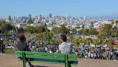
Geotab, a company devoted to "Internet of Things" (IoT) and transportation technology, has created a nifty little infographic that shows how much space is devoted to roads, green space, and buildings in 15 major cities.
The infographic uses OpenStreetMap data and U.S. Census population estimates to generate the infographic, allowing comparisons between cities like Boston, Chicago, Dallas, and San Francisco. Population density and space allocation are easily visible. The infographic is also sortable by space devoted to roads, green space, and buildings.
FULL STORY: Urban Footprint


Pop Quiz: Can You Identify Cities By Density Alone?
A Planetizen editor failed this quiz.
Is This Urbanism?
Chuck Wolfe ponders a recommended subscription list of Substack urbanists and wonders — as have others — about the utility of the "urbanist" moniker.

Survey: US Public Spaces Not Meeting Community Needs
A lack of funding prevents many U.S. parks and public spaces from playing a more significant role in helping residents meet daily needs.

Planetizen Federal Action Tracker
A weekly monitor of how Trump’s orders and actions are impacting planners and planning in America.

Maui's Vacation Rental Debate Turns Ugly
Verbal attacks, misinformation campaigns and fistfights plague a high-stakes debate to convert thousands of vacation rentals into long-term housing.

San Francisco Suspends Traffic Calming Amidst Record Deaths
Citing “a challenging fiscal landscape,” the city will cease the program on the heels of 42 traffic deaths, including 24 pedestrians.

Defunct Pittsburgh Power Plant to Become Residential Tower
A decommissioned steam heat plant will be redeveloped into almost 100 affordable housing units.

Trump Prompts Restructuring of Transportation Research Board in “Unprecedented Overreach”
The TRB has eliminated more than half of its committees including those focused on climate, equity, and cities.

Amtrak Rolls Out New Orleans to Alabama “Mardi Gras” Train
The new service will operate morning and evening departures between Mobile and New Orleans.
Urban Design for Planners 1: Software Tools
This six-course series explores essential urban design concepts using open source software and equips planners with the tools they need to participate fully in the urban design process.
Planning for Universal Design
Learn the tools for implementing Universal Design in planning regulations.
Heyer Gruel & Associates PA
JM Goldson LLC
Custer County Colorado
City of Camden Redevelopment Agency
City of Astoria
Transportation Research & Education Center (TREC) at Portland State University
Jefferson Parish Government
Camden Redevelopment Agency
City of Claremont