


A dataset on health measures in U.S. cities shows the difference in life expectancy between two Chicago neighborhoods is 30 years.

Jamiles Lartey reports on an analysis of health outcomes in U.S. cities that shows the biggest discrepancy in life expectancy between two neighborhoods in a city is in Chicago. "In predominantly white Streeterville, Chicagoans can expect to live to 90. In Englewood, where the population is virtually all black, life expectancy is just 60."
The City Health Dashboard is a project from NYU Langone Health that has compiled data on a series of health measures for the 500 largest American cities. The 30-year gap in life expectancy in Chicago highlights the extreme differences that can exist within the same city as a result of factors such as poverty, access to health care, and violence.
In Englewood, public health researchers are trying to understand what is driving the problematic health outcomes, writes Lartey:
[Rodney] Johnson is one member of a team of "community health navigators" who this week began conducting a door-to-door survey. One of the most pressing questions they’re trying to answer is why there seems to be a disconnect between services that are actually available in the community and residents who do not use them.
Lartey notes that while the situation in Englewood is dire, residents are also taking initiative to improve health and the quality of life in their neighborhood. Empty lots have become gardens and community spaces, residents advocated to bring a Whole Foods into Englewood, and nonprofit organizations are working with youth to address gun violence.
FULL STORY: 'It's totally unfair': Chicago, where the rich live 30 years longer than the poor

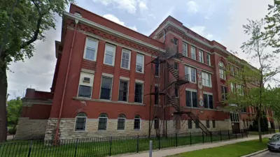
Historic Chicago School Building to Become Affordable Housing
The adaptive reuse project will create 50 income-restricted housing units and community amenities.
Planning for the 'Non-606': The Englewood Line
Englewood is a predominately black neighborhood in Chicago, struggling with vacancies and the effects of failed urban policies. A bike and pedestrian path could be a huge benefit, but that benefit would look a lot different than other parts of city.
High Hopes for New Developments in the Chicago Neighborhood of Englewood
Chicago's Englewood neighborhood recently saw the opening of a Whole Foods, Starbucks, and other retailers in a bit of a good news, for a neighborhood that's challenged by low employment and high violence.

Maui's Vacation Rental Debate Turns Ugly
Verbal attacks, misinformation campaigns and fistfights plague a high-stakes debate to convert thousands of vacation rentals into long-term housing.

Planetizen Federal Action Tracker
A weekly monitor of how Trump’s orders and actions are impacting planners and planning in America.

In Urban Planning, AI Prompting Could be the New Design Thinking
Creativity has long been key to great urban design. What if we see AI as our new creative partner?

King County Supportive Housing Program Offers Hope for Unhoused Residents
The county is taking a ‘Housing First’ approach that prioritizes getting people into housing, then offering wraparound supportive services.

Researchers Use AI to Get Clearer Picture of US Housing
Analysts are using artificial intelligence to supercharge their research by allowing them to comb through data faster. Though these AI tools can be error prone, they save time and housing researchers are optimistic about the future.

Making Shared Micromobility More Inclusive
Cities and shared mobility system operators can do more to include people with disabilities in planning and operations, per a new report.
Urban Design for Planners 1: Software Tools
This six-course series explores essential urban design concepts using open source software and equips planners with the tools they need to participate fully in the urban design process.
Planning for Universal Design
Learn the tools for implementing Universal Design in planning regulations.
planning NEXT
Appalachian Highlands Housing Partners
Mpact (founded as Rail~Volution)
City of Camden Redevelopment Agency
City of Astoria
City of Portland
City of Laramie