


Communities need accurate maps and more access to data to increase flood resilience—but right now FEMA's not providing that.
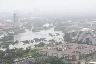
Across America, millions of families live in homes that are susceptible to flooding. And millions more could be at risk by the end of the century as the seas continue to rise and extreme weather events become more common. The National Flood Insurance Program (NFIP), for better or worse, plays a central role in the nation’s ability to address this growing threat.
Unfortunately, the federal flood insurance program has severe shortcomings—it has inaccurate and backward-looking flood maps, it’s not overly transparent about its flood risk and flood history data, and it doesn’t place enough emphasis on the importance of mitigation. These issues undermine everyone’s ability to accommodate and prepare for the damage wreaked to people’s homes by floods that are exacerbated by climate change. Homeowners and renters are left in the dark about their flood risk. This affects the community development field as well—affordable housing developers don’t have all the information they need to make siting and design decisions, and affordable housing lenders don’t have the information they need to appropriately underwrite flood-risk. This information gap distorts market signals, hinders fully informed decision making, and can lead to families being trapped in a nightmarish version of Groundhog Day: flooding, rebuilding, and repeating.
Congressional reform of the NFIP could help alleviate these problems, beginning with modernizing maps.
FULL STORY: The Uncertain Flood Zone


FEMA Resilience Program Cuts Grant Funding
The Building Resilient Infrastructure and Communities program funded projects from flood prevention to power station upgrades.

Rising Above: Innovative Solutions for Waikīkī’s Sea-Level Challenges
The University of Hawaiʻi at Mānoa’s award-winning Waikīkī sea-level rise adaptation project combines science, architecture, and community input to create scalable solutions for climate resilience and coastal flood mitigation.
America’s Housing Crisis: Lessons Ignored and Challenges Ahead
A recent study reveals how decades of policy missteps, demographic shifts, and economic forces fueled America’s housing crisis, leaving millions — especially millennials — struggling amid rising demand, racial disparities, and climate-driven emergencies.

Maui's Vacation Rental Debate Turns Ugly
Verbal attacks, misinformation campaigns and fistfights plague a high-stakes debate to convert thousands of vacation rentals into long-term housing.

Planetizen Federal Action Tracker
A weekly monitor of how Trump’s orders and actions are impacting planners and planning in America.

In Urban Planning, AI Prompting Could be the New Design Thinking
Creativity has long been key to great urban design. What if we see AI as our new creative partner?

King County Supportive Housing Program Offers Hope for Unhoused Residents
The county is taking a ‘Housing First’ approach that prioritizes getting people into housing, then offering wraparound supportive services.

Researchers Use AI to Get Clearer Picture of US Housing
Analysts are using artificial intelligence to supercharge their research by allowing them to comb through data faster. Though these AI tools can be error prone, they save time and housing researchers are optimistic about the future.

Making Shared Micromobility More Inclusive
Cities and shared mobility system operators can do more to include people with disabilities in planning and operations, per a new report.
Urban Design for Planners 1: Software Tools
This six-course series explores essential urban design concepts using open source software and equips planners with the tools they need to participate fully in the urban design process.
Planning for Universal Design
Learn the tools for implementing Universal Design in planning regulations.
planning NEXT
Appalachian Highlands Housing Partners
Mpact (founded as Rail~Volution)
City of Camden Redevelopment Agency
City of Astoria
City of Portland
City of Laramie