


The Sewerage & Water Board of New Orleans has launched its first public dashboards to track its operations and initiatives.

The Sewerage & Water Board of New Orleans recently announced the launch of new public dashboards to track operations and initiatives:
These initial dashboards will track the total number of active residential, commercial and industrial customer accounts, and the progress to reduce the number of bills under investigation for irregularities. Future dashboards are being developed to track a host of data, including Customer Service metrics, progress in hiring new employees, repairing water system leaks and operational status of the drainage system. Other aspects of the S&WB's mission will be added in time to promote transparency and responsiveness to customers and the public.
For fans of maps (or New Orleans, or both), the dashboard illustrates one of the unseen characteristics of the city, with an interactive map showing the age of water mains. The other dashboards indicate how many residents and business are relying on the city's water infrastructure.
FULL STORY: Data and Statistics

Texans to Vote on Flood Control Funding, Property Tax Breaks in Disaster Areas
The fingerprint of Hurricane Harvey and recurring flooding events around the state are evident in the statewide election in Texas on November 5, 2019.
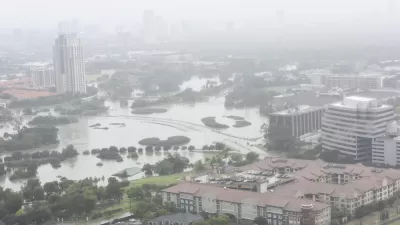
Can New Leadership Deliver New Stormwater and Sewer Systems in New Orleans?
The new head of the Sewage & Water Board of New Orleans comes to the job from Milwaukee, and he already has big ideas about what the city must do to prevent flooding like it experienced last summer.
Restoring Northern India’s Himalayan ‘Water Temples’
Thousands of centuries-old buildings protect the region’s natural springs and serve as community wells and gathering places.

Planetizen Federal Action Tracker
A weekly monitor of how Trump’s orders and actions are impacting planners and planning in America.

Maui's Vacation Rental Debate Turns Ugly
Verbal attacks, misinformation campaigns and fistfights plague a high-stakes debate to convert thousands of vacation rentals into long-term housing.

San Francisco Suspends Traffic Calming Amidst Record Deaths
Citing “a challenging fiscal landscape,” the city will cease the program on the heels of 42 traffic deaths, including 24 pedestrians.

Defunct Pittsburgh Power Plant to Become Residential Tower
A decommissioned steam heat plant will be redeveloped into almost 100 affordable housing units.

Trump Prompts Restructuring of Transportation Research Board in “Unprecedented Overreach”
The TRB has eliminated more than half of its committees including those focused on climate, equity, and cities.

Amtrak Rolls Out New Orleans to Alabama “Mardi Gras” Train
The new service will operate morning and evening departures between Mobile and New Orleans.
Urban Design for Planners 1: Software Tools
This six-course series explores essential urban design concepts using open source software and equips planners with the tools they need to participate fully in the urban design process.
Planning for Universal Design
Learn the tools for implementing Universal Design in planning regulations.
Heyer Gruel & Associates PA
JM Goldson LLC
Custer County Colorado
City of Camden Redevelopment Agency
City of Astoria
Transportation Research & Education Center (TREC) at Portland State University
Jefferson Parish Government
Camden Redevelopment Agency
City of Claremont