


With a plan to build a Trinity Toll Road a thing of the past, there are now two plans for parks along the Trinity River. One would "rewild" the watershed.
Peter Simek provides in-depth coverage of the current state of park and open space planning along the Trinity River in Dallas.
Plans first announced in 2016 for a new park designed by acclaimed landscape architect Michael van Valkenburgh lead to the "creation of a new quasi-governmental agency—a Local Governmental Corporation—to oversee the construction of the new park," explains Simek. As reported in 2017, river boosters lead by former councilmember Angela Hunt have also hatched plans for another park.
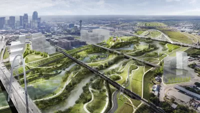
The planned Harold Simmons Park is only slated to be constructed between a 200-acre section of the floodway between the Ron Kirk Pedestrian Bridge and Interstate 30, a relatively small portion of the overall floodplain. What if there was a way to extend the restoration of the floodplain to a greater portion of the floodway?
Simek adds:
Since that time, Hunt and her collaborators have been kicking the tires and gathering supporters that include the National Audubon Society, which also helped coordinate last Saturday’s initial meeting. The group has identified a portion of the Trinity just north of the planned Simmons Park—between the Kirk Bridge and the Sylvan Avenue overpass (but excluding the existing Trammel Crow Park in the floodway). They believe this area can be restored into the kind of river-driven landscape that once characterized the Trinity floodplain before humans settled it.
Simek examines the politics of planning along the Trinity River, while also describing the planning and visioning exercises of the multiple groups working to implement a new vision for the Trinity River.
FULL STORY: Dallas May Now Get Two New Trinity River Parks

A Closer Look at the Big Park Plans Along Dallas' Trinity River
The Trinity River Project is coming into focus, after years of planning and decades of discussion. A $50 million donation in 2016 provided a big boost for Dallas' ambitious plans.
Is This the Trinity Park Plan of Dallas' Dreams?
Architecture critic Mark Lamster finally sees a proposal worth cheering for in Dallas' plans for a new park along the Trinity River.
Critic Sees 'Dallas Logic' in Latest Trinity River Plans
Mark Lamster has eviscerated the city of Dallas for its plans to build the Trinity Toll Road before—and he'll probably do it again.

Planetizen Federal Action Tracker
A weekly monitor of how Trump’s orders and actions are impacting planners and planning in America.

Maui's Vacation Rental Debate Turns Ugly
Verbal attacks, misinformation campaigns and fistfights plague a high-stakes debate to convert thousands of vacation rentals into long-term housing.

San Francisco Suspends Traffic Calming Amidst Record Deaths
Citing “a challenging fiscal landscape,” the city will cease the program on the heels of 42 traffic deaths, including 24 pedestrians.

Amtrak Rolls Out New Orleans to Alabama “Mardi Gras” Train
The new service will operate morning and evening departures between Mobile and New Orleans.

The Subversive Car-Free Guide to Trump's Great American Road Trip
Car-free ways to access Chicagoland’s best tourist attractions.

San Antonio and Austin are Fusing Into one Massive Megaregion
The region spanning the two central Texas cities is growing fast, posing challenges for local infrastructure and water supplies.
Urban Design for Planners 1: Software Tools
This six-course series explores essential urban design concepts using open source software and equips planners with the tools they need to participate fully in the urban design process.
Planning for Universal Design
Learn the tools for implementing Universal Design in planning regulations.
Heyer Gruel & Associates PA
JM Goldson LLC
Custer County Colorado
City of Camden Redevelopment Agency
City of Astoria
Transportation Research & Education Center (TREC) at Portland State University
Jefferson Parish Government
Camden Redevelopment Agency
City of Claremont