


Where is gentrification most likely to occur in cities like Detroit? And how can that data guide policy? A new report provides some insight.
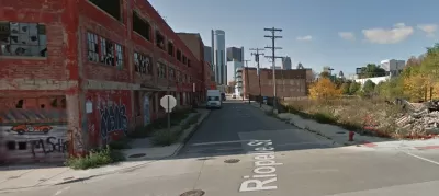
Pete Saunders discusses the first report out of the Turning the Corner project, which examines where gentrification is likely to occur in Detroit. The initiative is a joint effort between the National Neighborhood Indicators Partnership and local organizations in Detroit, Milwaukee, Phoenix, and the Twin Cities. In the Motor City's case, Data Driven Detroit is the local partner.
For the report, "the researchers developed what they called a Neighborhood Change Index Score for all Census block groups in Detroit, ranking them in terms of likelihood of neighborhood change from lowest to highest."
In addition to neighborhoods close to downtown, the report suggests that "a wide swath of the city's northeast side" is vulnerable to gentrification. Saunders notes: "that part of the city is known for its modest homes and stable, longtime homeowners, but also for a lack of investment."
He also points out that the report excludes areas where few residents live. "A simple Google search of 'Detroit empty blocks' would reveal large-scale former residential areas that, once the city and developers figure out how to unwind the tangle of ownership, might become new revitalization hotspots -- without the specter of immediate displacement."
FULL STORY: Anticipating -- And Preparing For -- Gentrification


Placemaking in the Barrio: Conceptualizing Infill Development in Disenfranchised Communities
How one San Antonio neighborhood could approach sustainable revitalization while supporting the existing community and drawing on its rich and diverse history and cultural resources.

Who’s To Blame for Gentrification?
Most likely, no one in particular—but policy changes can alleviate the housing shortage and prevent displacement.

Houston's East River Redevelopment Threatens Historic Black Neighborhoods
Longtime residents are being left behind by new development that has raised housing costs and property taxes for some of Houston's most vulnerable communities, according to an article in the Houston Chronicle.

Planetizen Federal Action Tracker
A weekly monitor of how Trump’s orders and actions are impacting planners and planning in America.

Chicago’s Ghost Rails
Just beneath the surface of the modern city lie the remnants of its expansive early 20th-century streetcar system.

San Antonio and Austin are Fusing Into one Massive Megaregion
The region spanning the two central Texas cities is growing fast, posing challenges for local infrastructure and water supplies.

Since Zion's Shuttles Went Electric “The Smog is Gone”
Visitors to Zion National Park can enjoy the canyon via the nation’s first fully electric park shuttle system.

Trump Distributing DOT Safety Funds at 1/10 Rate of Biden
Funds for Safe Streets and other transportation safety and equity programs are being held up by administrative reviews and conflicts with the Trump administration’s priorities.

German Cities Subsidize Taxis for Women Amid Wave of Violence
Free or low-cost taxi rides can help women navigate cities more safely, but critics say the programs don't address the root causes of violence against women.
Urban Design for Planners 1: Software Tools
This six-course series explores essential urban design concepts using open source software and equips planners with the tools they need to participate fully in the urban design process.
Planning for Universal Design
Learn the tools for implementing Universal Design in planning regulations.
planning NEXT
Appalachian Highlands Housing Partners
Mpact (founded as Rail~Volution)
City of Camden Redevelopment Agency
City of Astoria
City of Portland
City of Laramie