


Introducing the Cuyahoga Greenway plan, in the initial stages of visioning and public engagement in Northeast Ohio.
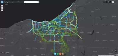
Steven Litt reports on the ongoing planning and design process for the Cuyahoga Greenway Framework Plan, which he describes as an ambitious piece of a larger effort to retrofit a region built for the car.
The current vision for the Cuyahoga Greenways is "a vast grid designed to connect the county's 59 communities to each other, to downtown Cleveland, the Lake Erie shoreline, the Towpath Trail in the Cuyahoga Valley, adjacent counties, and regions far beyond Northeast Ohio," explains Litt, encompassing "hundreds of miles of trails, greenways and bike paths."
The planning process is entering a public engagement phase, with a series of public hearings, listening sessions, and an online survey. "The public can also access a detailed online planning tool that enables users to zoom in on a highly detailed map of the proposed greenway network," according to Litt.
The article includes additional details about how the planning process has been funded, professional partners on the planning process, the original inspiration for the plan, and more about the broad ambitions the plan represents.
FULL STORY: Cuyahoga County seeks public input on greenways that would retrofit a region designed for the car

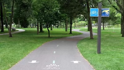
How to Make Greenways Better
Adding amenities such as public restrooms and shade trees can make greenways like Detroit’s Joe Louis Greenway more inviting and comfortable for their users.
Study: Cuyahoga County Suburbs Ready for TOD
The growth of transit-oriented development in the Cleveland region is being hindered by zoning codes that limit housing density and excessive parking requirements that drive up construction costs, new research suggests.

Freeway Cap Park Proposed in the Heart of Cleveland
A proposal to cap part of the Innerbelt Freeway east of Downtown Cleveland would require the demolition of a vacant, historic courthouse near the East 22nd Street Bridge.

Maui's Vacation Rental Debate Turns Ugly
Verbal attacks, misinformation campaigns and fistfights plague a high-stakes debate to convert thousands of vacation rentals into long-term housing.

Planetizen Federal Action Tracker
A weekly monitor of how Trump’s orders and actions are impacting planners and planning in America.

San Francisco Suspends Traffic Calming Amidst Record Deaths
Citing “a challenging fiscal landscape,” the city will cease the program on the heels of 42 traffic deaths, including 24 pedestrians.

Defunct Pittsburgh Power Plant to Become Residential Tower
A decommissioned steam heat plant will be redeveloped into almost 100 affordable housing units.

Trump Prompts Restructuring of Transportation Research Board in “Unprecedented Overreach”
The TRB has eliminated more than half of its committees including those focused on climate, equity, and cities.

Amtrak Rolls Out New Orleans to Alabama “Mardi Gras” Train
The new service will operate morning and evening departures between Mobile and New Orleans.
Urban Design for Planners 1: Software Tools
This six-course series explores essential urban design concepts using open source software and equips planners with the tools they need to participate fully in the urban design process.
Planning for Universal Design
Learn the tools for implementing Universal Design in planning regulations.
Heyer Gruel & Associates PA
JM Goldson LLC
Custer County Colorado
City of Camden Redevelopment Agency
City of Astoria
Transportation Research & Education Center (TREC) at Portland State University
Jefferson Parish Government
Camden Redevelopment Agency
City of Claremont