


San Francisco Chronicle urban design critic John King reveals more than one layer of planning significance from a project proposed near one of the city's most prominent, but underutilized, intersections.
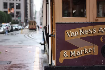
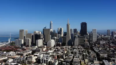
John King tells the story of changes coming to the intersection of Market Street and Van Ness Avenue in San Francisco—a conspicuous location on a map, but one that’s less so in reality.
The city is hoping to change that with a district plan called the Hub, which would include "a cluster of towers on the skyline, a variety of public spaces below and as many as 7,280 housing units in between," writes King. The first project that fits that new vision for the area, 1500 Mission St, by developer Related California, could be approved next week. Planning for the Hub, meanwhile, could enter environmental review this summer.
1500 Mission St. will build a 39-story apartment tower on the 2.5-acre site, along with a 16-story office complex for city employees. In between the two buildings, "there would be walkways lined with retail space in the base of the residential tower and meeting rooms, and an art gallery in the office building."
King examines the project as a case study of a project built at several crossroads, both literal and metaphorical. Here, old planning mandates, like a prohibition on construction that worsens wind on the sidewalks on Van Ness, combine with a higher density vision for the future of the area. King adds a final thought to summarize the broader stakes involved with the 1500 Mission St. proposal, as an incremental step in a taller, more dense future: "as the city revises plans for this small district and other parts of San Francisco, it isn’t enough to say that density is good as long as we get measurable benefits in return."
FULL STORY: Ambitious plan for once-central S.F. crossroads

San Francisco's 1971 Urban Design Plan Echoes Today's Concerns
A 1971 effort to quantify the city's values and design goals reflects many of the same priorities that planners and residents face today.
Opinion: What San Francisco’s Proposed ‘Family Zoning’ Could Really Mean
Mayor Lurie is using ‘family zoning’ to encourage denser development and upzoning — but could the concept actually foster community and more human-scale public spaces?
San Francisco Plans for 82,000 New Housing Units
California housing regulators have granted preliminary approval for the city of San Francisco’s housing element as mandated by the state’s Regional Housing Needs Allocation process.

Maui's Vacation Rental Debate Turns Ugly
Verbal attacks, misinformation campaigns and fistfights plague a high-stakes debate to convert thousands of vacation rentals into long-term housing.

Planetizen Federal Action Tracker
A weekly monitor of how Trump’s orders and actions are impacting planners and planning in America.

In Urban Planning, AI Prompting Could be the New Design Thinking
Creativity has long been key to great urban design. What if we see AI as our new creative partner?

King County Supportive Housing Program Offers Hope for Unhoused Residents
The county is taking a ‘Housing First’ approach that prioritizes getting people into housing, then offering wraparound supportive services.

Researchers Use AI to Get Clearer Picture of US Housing
Analysts are using artificial intelligence to supercharge their research by allowing them to comb through data faster. Though these AI tools can be error prone, they save time and housing researchers are optimistic about the future.

Making Shared Micromobility More Inclusive
Cities and shared mobility system operators can do more to include people with disabilities in planning and operations, per a new report.
Urban Design for Planners 1: Software Tools
This six-course series explores essential urban design concepts using open source software and equips planners with the tools they need to participate fully in the urban design process.
Planning for Universal Design
Learn the tools for implementing Universal Design in planning regulations.
planning NEXT
Appalachian Highlands Housing Partners
Mpact (founded as Rail~Volution)
City of Camden Redevelopment Agency
City of Astoria
City of Portland
City of Laramie