


It is indeed possible to have a city full of low-rise buildings that is still compact enough for excellent transit service—but only if most side streets are used for mid-rise buildings instead of houses.

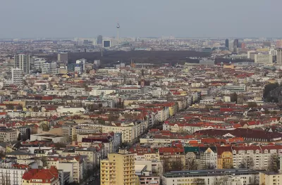
Many urbanists, especially those who dislike tall buildings, are eager to point out that a city can have dense, transit-oriented development without having lots of tall buildings. And when I visited Europe last month, I saw some excellent examples of low-rise yet compact places. Most of central Paris, for example, is dominated by four- and five-story buildings, yet Paris is actually denser than New York City. The older parts of Berlin and Amsterdam have a similar urban fabric.
Does this mean that American cities will be as walkable and transit-friendly as Paris if they halt the construction of tall buildings? Not exactly.
Here’s why: in the parts of central Paris and central Berlin that I visited, every single block was dominated by mid-rise buildings—not just busy multi-lane boulevards, but quiet residential streets as well. So if you walk through Charlottenberg (an affluent Berlin neighborhood) you will see street after street after street of three-to-five story buildings.
By contrast, no U.S. city outside Manhattan has a similar level of density on its side streets. Even New York's outer boroughs have some streets with lots of mid-rises, but many others that are dominated by single-family homes or rowhouses. And in less compact American cities, the overwhelming majority of streets are dominated by single-family homes. So to have a European level of density, a city must either rezone all of its side streets to allow lots of multi-story, multi-family low-rise buildings, or allow taller buildings on its main streets.
For example, Charlottenberg has 118,704 people living in about 2,500 acres (that is, four square miles). Thus, it has slightly over 47 people per acre, fairly evenly distributed across the neighborhood’s blocks. Suppose that 2,300 of these acres were magically turned into a walkable American streetcar suburb—for example, Atlanta’s Virginia Highlands, a walkable neighborhood dominated by single-family homes. Virginia-Highlands has 7,800 inhabitants living on 612 acres, or 12 people per acre, so the population of these 2,300 acres would be reduced from 108,000 to just under 28,000. To avoid reducing neighborhood-wide density, the other 200 acres would have to be upzoned to support about 80,000 additional inhabitants—which means that instead of having around 10,000 inhabitants, the neighborhood’s most dense streets would have 90,000 people, or almost 450 per acre, a significantly higher level of density than Manhattan.* Could you have 450 people per acre without having some high-rises? I doubt it.
In sum, you might want a city with Paris/Berlin densities, streets full of single-family homes, and without high-rises. But in fact, you can only have two of the three. You can have a dense low-rise city, but only if almost all of the streets were dominated by multi-story buildings (the European option). Or you can have a city with single-family zoning and fairly high density, but only if you have lots of tall buildings on the multifamily blocks.
*Manhattan has 51 households per acre, or roughly 100-150 human beings per acre. However, some blocks in my Manhattan neighborhood (Murray Hill) have 100-150 households per acre, which is a bit closer to this density level.

Orange County, Florida Adopts Largest US “Sprawl Repair” Code
The ‘Orange Code’ seeks to rectify decades of sprawl-inducing, car-oriented development.
Texas Legislature’s Surprising Pro-Housing Swing
Smaller homes on smaller lots, office to apartment conversions, and 40% less say for NIMBYs, vote state lawmakers.
Judge Rules in Favor of Massachusetts TOD Law
The court rejected an argument that the MBTA Communities law, which requires zoning for multifamily housing, is an “unfunded mandate.”

Planetizen Federal Action Tracker
A weekly monitor of how Trump’s orders and actions are impacting planners and planning in America.

Maui's Vacation Rental Debate Turns Ugly
Verbal attacks, misinformation campaigns and fistfights plague a high-stakes debate to convert thousands of vacation rentals into long-term housing.

San Francisco Suspends Traffic Calming Amidst Record Deaths
Citing “a challenging fiscal landscape,” the city will cease the program on the heels of 42 traffic deaths, including 24 pedestrians.

Amtrak Rolls Out New Orleans to Alabama “Mardi Gras” Train
The new service will operate morning and evening departures between Mobile and New Orleans.

The Subversive Car-Free Guide to Trump's Great American Road Trip
Car-free ways to access Chicagoland’s best tourist attractions.

San Antonio and Austin are Fusing Into one Massive Megaregion
The region spanning the two central Texas cities is growing fast, posing challenges for local infrastructure and water supplies.
Urban Design for Planners 1: Software Tools
This six-course series explores essential urban design concepts using open source software and equips planners with the tools they need to participate fully in the urban design process.
Planning for Universal Design
Learn the tools for implementing Universal Design in planning regulations.
Heyer Gruel & Associates PA
JM Goldson LLC
Custer County Colorado
City of Camden Redevelopment Agency
City of Astoria
Transportation Research & Education Center (TREC) at Portland State University
Jefferson Parish Government
Camden Redevelopment Agency
City of Claremont