


Satellite images make some of the best maps.
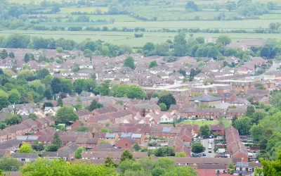
A post on the website of the Local Authority of Building Control (LABC) in the United Kingdom has produced a new map that uses high definition satellite images to plot the different kinds of land development in the United Kingdom.
The maps were created with Corine (coordination of information on the environment) Land Cover data from 2012 which includes 44 different types of land classification including:
- ‘continuous urban fabric’: used to describe the most built up urban areas
- ‘industrial and commercial units’
- ‘green urban’: golf courses, football pitches, parks etc
- ‘farmland’: pasture, arable land, vineyards, orchards
- ‘natural’: moors, forests, lakes
According to the article, the "continuous urban fabric" designation, which applies to areas where 80-100% of the land surface is built on, only accounts for o.1 percent of the land in the United Kingdom. "Another category called 'discontinuous urban fabric', places where between 50% and 80% of the land surface is built on accounts for a mere 5.6%."
Hat tip to H. Pike Oliver for sharing the link to the LABC's post.
FULL STORY: UK land use laid bare by satellite images


Commentary: Why We Need a Federal Definition of ‘Rural’
A patchwork of definitions of rural versus urban areas has real consequences for communities seeking federal funding.

How the Built Environment Affects Your Mood
Humans have survived for millennia by staying together, not apart.

Opinion: Ohio Needs Public Transit
A new Intel facility is set to bring thousands of workers to rural Ohio. Will the state embrace mass transit or give in to auto-centric sprawl?

Planetizen Federal Action Tracker
A weekly monitor of how Trump’s orders and actions are impacting planners and planning in America.

Congressman Proposes Bill to Rename DC Metro “Trump Train”
The Make Autorail Great Again Act would withhold federal funding to the system until the Washington Metropolitan Area Transit Authority (WMATA), rebrands as the Washington Metropolitan Authority for Greater Access (WMAGA).

The Simple Legislative Tool Transforming Vacant Downtowns
In California, Michigan and Georgia, an easy win is bringing dollars — and delight — back to city centers.

The States Losing Rural Delivery Rooms at an Alarming Pace
In some states, as few as 9% of rural hospitals still deliver babies. As a result, rising pre-term births, no adequate pre-term care and "harrowing" close calls are a growing reality.

The Small South Asian Republic Going all in on EVs
Thanks to one simple policy change less than five years ago, 65% of new cars in this Himalayan country are now electric.

DC Backpedals on Bike Lane Protection, Swaps Barriers for Paint
Citing aesthetic concerns, the city is removing the concrete barriers and flexposts that once separated Arizona Avenue cyclists from motor vehicles.
Urban Design for Planners 1: Software Tools
This six-course series explores essential urban design concepts using open source software and equips planners with the tools they need to participate fully in the urban design process.
Planning for Universal Design
Learn the tools for implementing Universal Design in planning regulations.
Smith Gee Studio
City of Charlotte
City of Camden Redevelopment Agency
City of Astoria
Transportation Research & Education Center (TREC) at Portland State University
US High Speed Rail Association
City of Camden Redevelopment Agency
Municipality of Princeton (NJ)