


Walkable cities with strong downtowns are closing the economic gap with suburbia, while sprawling cities—even those with high population growth—are not doing as well.

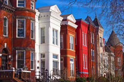
Pete Saunders, author of the Corner Side Yard blog, has engaged in an enormous amount of research regarding the economic disparities between cities and suburbs. In particular, one of his recent articles has shown that in ten of the fourteen largest urbanized areas, the gap between city and suburban median household incomes is narrower than in 2000. For example, in 2000, the median income in Washington, D.C. was 62.8 percent of regional income; by 2015, the city's household income had grown to 79.3 percent of regional income. However, such gentrification was less common in urbanized areas with 1-3 million people; 13 of 27 core cities in this group gained income relative to their suburbs. In all 41 regions with population over 1 million, city income grew from 79.8 percent of regional income to 81.3 percent of regional income. So if gentrification means "cities not being as poor relative to their suburbs as they were fifteen years ago," gentrification is undoubtedly real.
But to me the more interesting question is: which cities closed the income gap with their suburbs, and which were less successful? I looked at a variety of metrics, including:
Population growth.
I divided core cities of these regions* into three categories: those that had consistently lost population in recent decades (such as Detroit and Pittsburgh), those that had consistently gained population, and a middle group that had lost population during part or all of the late 20th century but had gained population since 2000. Only three of the eight population-losers (Pittsburgh, Chicago, and St. Louis) gained income relative to their suburbs, and only seven of the 18 population-gainers did so. By contrast, 12 of the 14 "rebounding cities" (that is, cities that lost population in the 1960s or 1970s but gained population more recently) gained income relative to their suburbs. Saunders points out that coastal cities generally made income gains, but this pattern cut across regional lines. Gentrifying rebound cities included mid-American cities such as Minneapolis and Atlanta as well as coastal cities such as San Francisco.
In other words, there is a strong correlation between gentrification and population growth—but only for cities that lost population for at least part of the late 20th century.
Car-centeredness.
I divided my sample into three groups: 17 extremely car-centered cities where under 5 percent of commuters used public transit to get to work, the six "transit metropolises" where over 20 percent of commuters take a train or bus (Boston, Chicago, New York, Philadelphia, Washington and San Francisco), and 17 "in between" cities where between 5 and 20 percent of commuters use transit.
City income increased relative to suburbia in all six of the most transit-oriented cities. By contrast, city income grew relative to suburbia in only five of the 17 "car cities." The "in-between cities" had in-between results: cities gained ground in 11 of the 17.
In other words, gentrification tends to happen in places where people are less likely to drive everywhere. In addition, there seemed to be a pretty strong correlation between density and income growth: of the ten central cities with fewer than 3000 people per square mile, seven declined relative to their suburbs. By contrast, all nine of the cities with over 8,000 people per square mile gained income.
Downtown strength.
The University of Virginia's Demographics Research Group has created a variety of charts that allow readers to compare downtowns with suburbs. To simplify matters, I focused on one variable: whether per-capita income downtown is higher than in the more prosperous rings of suburbia. I found 16 regions where per capita income in the one-mile ring (that is, income within a mile of the core) was higher than in any suburban ring. In 11 of those cities, citywide income grew relative to suburbia. By contrast, cities gained ground in only ten of the other cities. Interestingly, the only "strong downtown" cities where the city as a whole became poorer relative to suburbia were cities with very low public transit use: Charlotte, Columbus, Dallas, Houston and Tampa.
So how can I account for these divergences? One possible explanation is that people with money simply like to live in walkable regions with strong downtowns. Another possible explanation is that inner-ring midcentury suburbs are declining everywhere, but that "car cities" tend to be in states that have allowed cities to annex those suburbs, causing more declining areas to be within core city boundaries and causing citywide incomes to stagnate relative to suburbia.
Your thoughts, dear readers?
*I excluded one of the regions (Norfolk/Virginia Beach, Va.) listed in Saunders' article, because the larger of the two core cities (Virginia Beach) is a suburb of the smaller one (Norfolk).


New Poverty and Income Data Reveals a Tale of Two Types of Cities
While the country overall made progress, larger cities are making stronger gains against poverty.

Some Big Cities See Shrinking Rents
Even as rents continue to rise nationally, some of the most expensive cities like San Jose, San Francisco, and New York have seen rents fall this year.

Zillow: Suburbs Becoming More Like Cities
According to the real estate website, urban home values are growing faster than those in the suburbs, bucking a longtime trend. This isn't exactly surprising, but it has serious social justice implications.

Planetizen Federal Action Tracker
A weekly monitor of how Trump’s orders and actions are impacting planners and planning in America.

Maui's Vacation Rental Debate Turns Ugly
Verbal attacks, misinformation campaigns and fistfights plague a high-stakes debate to convert thousands of vacation rentals into long-term housing.

San Francisco Suspends Traffic Calming Amidst Record Deaths
Citing “a challenging fiscal landscape,” the city will cease the program on the heels of 42 traffic deaths, including 24 pedestrians.

Amtrak Rolls Out New Orleans to Alabama “Mardi Gras” Train
The new service will operate morning and evening departures between Mobile and New Orleans.

The Subversive Car-Free Guide to Trump's Great American Road Trip
Car-free ways to access Chicagoland’s best tourist attractions.

San Antonio and Austin are Fusing Into one Massive Megaregion
The region spanning the two central Texas cities is growing fast, posing challenges for local infrastructure and water supplies.
Urban Design for Planners 1: Software Tools
This six-course series explores essential urban design concepts using open source software and equips planners with the tools they need to participate fully in the urban design process.
Planning for Universal Design
Learn the tools for implementing Universal Design in planning regulations.
Heyer Gruel & Associates PA
JM Goldson LLC
Custer County Colorado
City of Camden Redevelopment Agency
City of Astoria
Transportation Research & Education Center (TREC) at Portland State University
Jefferson Parish Government
Camden Redevelopment Agency
City of Claremont