


The "Monitoring Global Urban Expansion Program" gathers and analyzes data on 200 cities around the world. The "Atlas of Urban Expansion" presents the program's preliminary results.

FULL STORY: Atlas of Urban Expansion

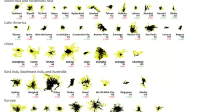
Mapping 25 Years of Urban Expansion
What comparing 25 years of urban expansion on six continents reveals about the changing nature of the built environment.
United Nations Taking First Steps Toward the New Urban Agenda
Some of the big work left undone by the Habitat III summit in finalizing the New Urban Agenda in December is now moving forward. The future of the New Urban Agenda and UN-Habitat can now start to take shape.
A New Kind of Planning for a New Kind of Africa
Ernest Harsch interviews UN-Habitat Director Joan Clos on the challenges facing African cities in an age of unprecedented urbanization, from the abundance of slums to the threat of natural disasters.

Planetizen Federal Action Tracker
A weekly monitor of how Trump’s orders and actions are impacting planners and planning in America.

Maui's Vacation Rental Debate Turns Ugly
Verbal attacks, misinformation campaigns and fistfights plague a high-stakes debate to convert thousands of vacation rentals into long-term housing.

Restaurant Patios Were a Pandemic Win — Why Were They so Hard to Keep?
Social distancing requirements and changes in travel patterns prompted cities to pilot new uses for street and sidewalk space. Then it got complicated.

In California Battle of Housing vs. Environment, Housing Just Won
A new state law significantly limits the power of CEQA, an environmental review law that served as a powerful tool for blocking new development.

Boulder Eliminates Parking Minimums Citywide
Officials estimate the cost of building a single underground parking space at up to $100,000.

Orange County, Florida Adopts Largest US “Sprawl Repair” Code
The ‘Orange Code’ seeks to rectify decades of sprawl-inducing, car-oriented development.
Urban Design for Planners 1: Software Tools
This six-course series explores essential urban design concepts using open source software and equips planners with the tools they need to participate fully in the urban design process.
Planning for Universal Design
Learn the tools for implementing Universal Design in planning regulations.
Heyer Gruel & Associates PA
JM Goldson LLC
Custer County Colorado
City of Camden Redevelopment Agency
City of Astoria
Transportation Research & Education Center (TREC) at Portland State University
Jefferson Parish Government
Camden Redevelopment Agency
City of Claremont