Treepedia is MIT's effort to collect a complete resource on the tree cover of city streets.

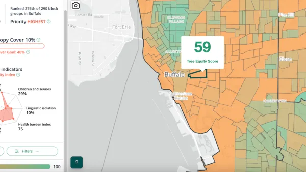
Treepedia is a growing resource on city trees. The website maps tree information onto visuals from Google Maps. "Rating a huge number of street corners for the relative greenery of their appearance, Treepedia also allows browsers to click on a series of dots that reveal street view images of the location in question," writes Feargus O'Sullivan for CityLab.
While the site currently only maps around ten cities, it's a growing resource that could someday contain information about streets all over the world. The tool should allow residents to compare neighborhoods within their cities and cities to each other. Giving a visual, quantifiable testament to tree cover may make it easier to examine the issue in terms that are concrete and compelling.
FULL STORY: Mapping the Urban Tree Canopy in Major Cities

Planetizen Federal Action Tracker
A weekly monitor of how Trump’s orders and actions are impacting planners and planning in America.

Maui's Vacation Rental Debate Turns Ugly
Verbal attacks, misinformation campaigns and fistfights plague a high-stakes debate to convert thousands of vacation rentals into long-term housing.

Cuomo Is the Candidate of Both NIMBYs and Developers. What Gives?
In the New York City mayoral race, odd bedfellows align to preserve the housing status quo.

Amtrak Rolls Out New Orleans to Alabama “Mardi Gras” Train
The new service will operate morning and evening departures between Mobile and New Orleans.

The Subversive Car-Free Guide to Trump's Great American Road Trip
Car-free ways to access Chicagoland’s best tourist attractions.

San Antonio and Austin are Fusing Into one Massive Megaregion
The region spanning the two central Texas cities is growing fast, posing challenges for local infrastructure and water supplies.
Urban Design for Planners 1: Software Tools
This six-course series explores essential urban design concepts using open source software and equips planners with the tools they need to participate fully in the urban design process.
Planning for Universal Design
Learn the tools for implementing Universal Design in planning regulations.
Heyer Gruel & Associates PA
JM Goldson LLC
Custer County Colorado
City of Camden Redevelopment Agency
City of Astoria
Transportation Research & Education Center (TREC) at Portland State University
Jefferson Parish Government
Camden Redevelopment Agency
City of Claremont


