


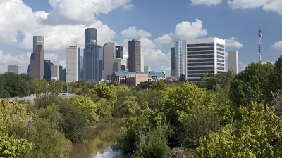
Houston's development has meant the loss of many wetlands, a key factor in protecting the against floods. This, coupled with climate change, will mean more floods, causing more danger and damage to the growing city.

Flooding is the most common natural disaster in the United States. It's a particular concern in Houston. "Scientists, other experts and federal officials say Houston's explosive growth is largely to blame. As millions have flocked to the metropolitan area in recent decades, local officials have largely snubbed stricter building regulations, allowing developers to pave over crucial acres of prairie land that once absorbed huge amounts of rainwater," report Neena Satija and Kiah Collier for Probulica. They go on to say, "Scientists say the Harris County Flood Control District, which manages thousands of miles of floodwater-evacuating bayous and helps enforce development rules, should focus more on preserving green space and managing growth."
This view of the problem is not shared by all of those in charge of protecting the city from flood damage. "Houston’s two top flood control officials say their biggest challenge is not managing rapid growth but retrofitting outdated infrastructure," the piece says. Mike Talbott thinks these scientists are engaged in some kind of conspiracy against development. "The longtime head of the flood control district flat-out disagrees with scientific evidence that shows development is making flooding worse." Talbott told the Texas Tribune, “They (scientists and conservationists) have an agenda ... their agenda to protect the environment overrides common sense,” Probulica reports. While Talbott is retiring, his view is not uncommon in the agency he ran for 18 years.
FULL STORY: Boomtown, Flood Town


Challenges in Rebuilding Houston Extend Beyond Development
Michael Kimmelman, architecture critic of The New York Times, looks beyond sprawl and development issues that challenge Houston in its rebuilding efforts. An anti-urban, anti-regulation bias from the statehouse isn't helping matters.

Up and Running: The Speedy Recovery of Houston's City Hall
Following Hurricane Harvey, Houston's City Hall became flooded with four feet of water, rendering the building's electrical and mechanical equipment useless. Restoring power back to City Hall quickly was crucial in aiding the recovery efforts.
Houston's Floods a Reminder of the Importance of Wetlands Protection
The executive director of the Bayou Land Conservancy takes to the pages of the Houston Chronicle to describe the conservationist and landscape-focused efforts that can prevent floods like those that struck Houston this week.

Planetizen Federal Action Tracker
A weekly monitor of how Trump’s orders and actions are impacting planners and planning in America.

Maui's Vacation Rental Debate Turns Ugly
Verbal attacks, misinformation campaigns and fistfights plague a high-stakes debate to convert thousands of vacation rentals into long-term housing.

Cuomo Is the Candidate of Both NIMBYs and Developers. What Gives?
In the New York City mayoral race, odd bedfellows align to preserve the housing status quo.

The Subversive Car-Free Guide to Trump's Great American Road Trip
Car-free ways to access Chicagoland’s best tourist attractions.

San Antonio and Austin are Fusing Into one Massive Megaregion
The region spanning the two central Texas cities is growing fast, posing challenges for local infrastructure and water supplies.

Charlottesville Temporarily Has No Zoning Code
A judge ordered the Virginia city to throw out its newly revised zoning code, leaving permitting for new development in legal limbo.
Urban Design for Planners 1: Software Tools
This six-course series explores essential urban design concepts using open source software and equips planners with the tools they need to participate fully in the urban design process.
Planning for Universal Design
Learn the tools for implementing Universal Design in planning regulations.
Heyer Gruel & Associates PA
JM Goldson LLC
Custer County Colorado
City of Camden Redevelopment Agency
City of Astoria
Transportation Research & Education Center (TREC) at Portland State University
Jefferson Parish Government
Camden Redevelopment Agency
City of Claremont