


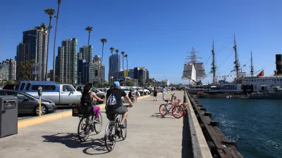
Downtown San Diego’s waterfront is undergoing major changes. Regarding the latest proposal, the San Diego Environment + Design Council has some words of advice in this open letter to the Port District.
The San Diego Unified Port District Commission has selected one of six proposals for a redevelopment of 77 acres of waterfront, including the popular Seaport Village. This redevelopment proposal would include, among other things, a 500-foot spire featuring a gondola ride, a beach, "an aquarium park," a pier, a floating pool, park space, a plaza for markets and events, an amphitheater, a dock for paddle boarding, a market area "similar to Pike Place," and, of course, retail space.
The San Diego Environment + Design Council, a coalition of organizations promoting environmentally-sustainable land use policies, has some concerns and advise:
Connect – The new waterfront area "should have obvious and functional physical and programmatic links to the downtown. . . continuation of the grid network to the water could enhance both the physical and visual connection to the Bay from the core, which is largely missing."
Not just for tourists – "include an array of tenants serving practical needs for downtown residents and displaying works of local artists."
Focus on the Bay – "The primary 'draw' should be San Diego Bay, and not shops and restaurants proximate to it."
Don’t overpower – "Proposed structures should not overwhelm the site with excessive bulk, excessive mass, excessive height, or crowding the waterfront by being too close to the edge."
Architecture – should be distinctive but should not distract from the beauty or history of the area – It should not be "a depiction of false history, nor something so trendy as to risk aging poorly."
Hotel set back – "hotels should not be in a waterfront park, but adjacent to it."
Retail and Restaurants – "...should assume a secondary position to the primary focus and purpose of the project site – free public access to, and the enjoyment of, San Diego Bay."
Multi-purpose public spaces – "public plazas [should] emphasize unprogrammed free play, quiet enjoyment, and San Diego Bay views, aromas, and sounds.”
Public art – "The public realm should have permanent fixed art of international prominence, and opportunities for outdoor performing arts."
Dynamic experiences – encourage "ever changing array of colorful outdoor building-free street vendors with carts, crafts, foods, and performances."
Timeless design – Require development with "high quality durability, flexibility, functionality, and material finish...Fine grain details..." with a "distinctive San Diego flavor."
Water Oriented Facilities – Include a public beach, "piers, overlooks, and wharves, free and open to the public.”
Commercial fishing operations – retain the tuna boat fleet—it provides an "authentic element . . . and link to San Diego’s maritime history."
Parking and mobility improvements:
PARK AND RIDE/WALK – "uses that require vehicle access for drop-offs, or service deliveries, [should be] positioned away from the waterside...."
And most importantly, part of the comprehensive planning process –
[A]n open and comprehensive planning and development process is essential. . . We recommend that no action on this particular parcel proceed until the Port District completes and adopts a Comprehensive Master Plan Update. The proposed project is an unacceptable, “piecemeal” development, instead of a component of an adopted update to the Comprehensive Master Plan.
FULL STORY: Open letter to San Diego Port Commission about “world class waterfront” development proposals


San Diego Votes to Rein in “Towering” ADUs
City council voted to limit the number of units in accessory buildings to six — after confronting backyard developments of up to 100 units behind a single family home.
ADUs for Sale? San Diego Could Legalize Backyard Condos
As one of 25 proposed amendments, San Diego may soon allow accessory dwelling units to be bought and sold as individual homes.
San Diego Adopts First Mobility Master Plan
The plan provides a comprehensive framework for making San Diego’s transportation network more multimodal, accessible, and sustainable.

Maui's Vacation Rental Debate Turns Ugly
Verbal attacks, misinformation campaigns and fistfights plague a high-stakes debate to convert thousands of vacation rentals into long-term housing.

Planetizen Federal Action Tracker
A weekly monitor of how Trump’s orders and actions are impacting planners and planning in America.

In Urban Planning, AI Prompting Could be the New Design Thinking
Creativity has long been key to great urban design. What if we see AI as our new creative partner?

King County Supportive Housing Program Offers Hope for Unhoused Residents
The county is taking a ‘Housing First’ approach that prioritizes getting people into housing, then offering wraparound supportive services.

Researchers Use AI to Get Clearer Picture of US Housing
Analysts are using artificial intelligence to supercharge their research by allowing them to comb through data faster. Though these AI tools can be error prone, they save time and housing researchers are optimistic about the future.

Making Shared Micromobility More Inclusive
Cities and shared mobility system operators can do more to include people with disabilities in planning and operations, per a new report.
Urban Design for Planners 1: Software Tools
This six-course series explores essential urban design concepts using open source software and equips planners with the tools they need to participate fully in the urban design process.
Planning for Universal Design
Learn the tools for implementing Universal Design in planning regulations.
planning NEXT
Appalachian Highlands Housing Partners
Mpact (founded as Rail~Volution)
City of Camden Redevelopment Agency
City of Astoria
City of Portland
City of Laramie