


Georgetown's grid of small blocks is starkly different from the L'Enfant-designed city that surrounds it.
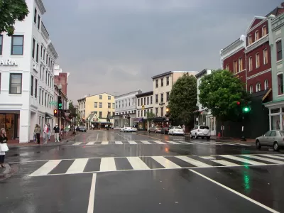
The origins of Washington, D.C.'s Georgetown neighborhood can be traced back to a Scottish man named Ninian Beall, who had the original grant for the land where the neighborhood would develop from a tobacco inspection station to a busy commercial port. Writing in Greater Greater Washington, Topher Mathews traces the history of the neighborhood to its eventual development into a grid comprised of small blocks.
The layout of Georgetown was a typical modest colonial town. The 80 lots were separated by only two streets and two narrow lanes. In the 1780s, several additions were annexed to the town.
...
While the physical structures hadn't filled in the street grid by the 1790s, Pierre L'Enfant nonetheless concluded that Georgetown was too developed with its own town plan to be incorporated into his Baroque plan for the city of Washington.
This design independence has survived to the present day as Georgetown lacks the circles and radials of the rest of downtown Washington.
Matthews notes that while Georgetown's original grid layout survived, many of its street names did not. As Washington, D.C. grew around it and eventually merged with it in 1872, many of the original street names were changed to match the D.C. street system.
FULL STORY: The story behind Georgetown's street grid


Is Washington D.C. Preserving Buildings or Hoarding Them?
A piecemeal, reactive approach to historic preservation in the capital may burden the future with too many buildings of "middling merit."
Georgetown-Rosslyn Gondola Proposal Gets a Funded Study
The idea of a gondola crossing the Potomac might still seem a little pie in the sky, but it has legs.
A New Future Proposed for Georgetown
After announcing its Georgetown 2028 Plan last year, the Georgetown Business Improvement District is continuing its ambitious efforts to bring new facilities and amenities online in Georgetown.

Maui's Vacation Rental Debate Turns Ugly
Verbal attacks, misinformation campaigns and fistfights plague a high-stakes debate to convert thousands of vacation rentals into long-term housing.

Planetizen Federal Action Tracker
A weekly monitor of how Trump’s orders and actions are impacting planners and planning in America.

In Urban Planning, AI Prompting Could be the New Design Thinking
Creativity has long been key to great urban design. What if we see AI as our new creative partner?

King County Supportive Housing Program Offers Hope for Unhoused Residents
The county is taking a ‘Housing First’ approach that prioritizes getting people into housing, then offering wraparound supportive services.

Researchers Use AI to Get Clearer Picture of US Housing
Analysts are using artificial intelligence to supercharge their research by allowing them to comb through data faster. Though these AI tools can be error prone, they save time and housing researchers are optimistic about the future.

Making Shared Micromobility More Inclusive
Cities and shared mobility system operators can do more to include people with disabilities in planning and operations, per a new report.
Urban Design for Planners 1: Software Tools
This six-course series explores essential urban design concepts using open source software and equips planners with the tools they need to participate fully in the urban design process.
Planning for Universal Design
Learn the tools for implementing Universal Design in planning regulations.
planning NEXT
Appalachian Highlands Housing Partners
Mpact (founded as Rail~Volution)
City of Camden Redevelopment Agency
City of Astoria
City of Portland
City of Laramie