


Designed by the same landscape architect behind New York City's High Line, a new park will cap San Francisco's Doyle Drive, connecting the Presidio to the shoreline.
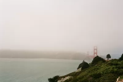
Nestled just south of the Golden Gate Bridge, a new section of parkland will connect the Presidio to the water. Nate Berg writes, "The Doyle Drive replacement, completed in 2015, is tucked inside concrete tunnels, the roofs of which will serve as green bridges linking the two sections of the Presidio that were separated in the 1930s." The cap park heals a physical divide that became very acute after the Presidio ceased its service as a U.S. Army base in 1994.
According to James Corner, of James Corner Field Operations, "'When you step out on the tunnel tops, you really get a 360-degree, geographical sort of centering vantage point where you can take in every landmark and every place that's significant in San Francisco and the bay.'" Corner's firm also designed New York's High Line, which has received significant attention and praise.
Covering freeways with parkland is an idea that has become increasingly popular nationwide. "In Dallas, for example, the 5.2‑acre Klyde Warren Park opened in 2012 on a platform over a sunken section of freeway. Los Angeles and Seattle are now considering similar freeway-cap parks."
FULL STORY: San Francisco’s Plan to Bury a Freeway


Maui's Vacation Rental Debate Turns Ugly
Verbal attacks, misinformation campaigns and fistfights plague a high-stakes debate to convert thousands of vacation rentals into long-term housing.

Planetizen Federal Action Tracker
A weekly monitor of how Trump’s orders and actions are impacting planners and planning in America.

Chicago’s Ghost Rails
Just beneath the surface of the modern city lie the remnants of its expansive early 20th-century streetcar system.

Bend, Oregon Zoning Reforms Prioritize Small-Scale Housing
The city altered its zoning code to allow multi-family housing and eliminated parking mandates citywide.

Amtrak Cutting Jobs, Funding to High-Speed Rail
The agency plans to cut 10 percent of its workforce and has confirmed it will not fund new high-speed rail projects.

LA Denies Basic Services to Unhoused Residents
The city has repeatedly failed to respond to requests for trash pickup at encampment sites, and eliminated a program that provided mobile showers and toilets.
Urban Design for Planners 1: Software Tools
This six-course series explores essential urban design concepts using open source software and equips planners with the tools they need to participate fully in the urban design process.
Planning for Universal Design
Learn the tools for implementing Universal Design in planning regulations.
planning NEXT
Appalachian Highlands Housing Partners
Mpact (founded as Rail~Volution)
City of Camden Redevelopment Agency
City of Astoria
City of Portland
City of Laramie