


Sprawl lowers real estate values in cheap, declining cities—but it may also have social costs that aren't as relevant elsewhere.


Most of what I have read about the relationship between sprawl and affordability seems to relate to high-cost cities. Arguments sometimes boil down to this exchange:
A (sprawl lobby/real estate developer/road-builder): isn’t sprawl wonderful? Building new highways opens up new land for development, creating cheaper housing for everybody!
B (environmentalist/urbanist): but what you gain in lower housing costs you lose in higher transportation costs, so on balance no one is better off. Plus, there are these pesky little things called environmental externalities.
(A and B throw statistics at each other until both die of exhaustion.)
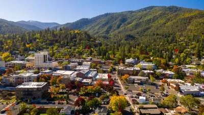
But most of this discussion seems to be relevant to growing, high-cost cities: desirable cities with high rents. How do these trade-offs play out in cheap, declining cities like those in America's Rust Belt? In such cities, government has been so successful in opening up new land for development that urban neighborhoods are littered with abandoned houses. In Cleveland, for example, the average house sells for just under $80,000, while the average house in suburban Geauga County costs more than three times that much. My zillow.com search found over a dozen Cleveland houses selling for under $5000—not counting lots for sale and foreclosure auctions.
Residents of Cleveland and similar cities suffer sprawl-related losses that they might not suffer in New York or Washington, including:
*Transportation costs. Because of the decline of transit service and the movement of jobs to suburbia, more Clevelanders must drive to work than in New York or Washington. So what city residents gain in housing costs, they may lose in transportation. According to the Center for Neighborhood Technology, city residents in Cleveland spend an average of $10,000 per household on transportation. If this statistic is accurate, city residents spend 1/4 of mean household income on transportation.
*Neighborhood decline. If you live in a stable suburb, you are no worse off in metropolitan Cleveland than in any other American suburb. But in a stagnant metro area, constant sprawl means constant neighborhood decline: today's good neighborhoods are tomorrow’s bad neighborhoods, as older neighborhoods and suburbs empty out and become poorer. So if you live in the city or in a not-so-stable suburb, the constant threat of a ruined neighborhood (and ruined property values) pursues you. In older Cleveland suburbs such as Warrensville Heights, South Euclid and Garfield Heights, home prices (measured by Zillow Zestimates) have declined by 30-40 percent since 2007; by contrast, in outer suburbs such as Solon, real estate prices are close to pre-recession highs.
If you live in a poor neighborhood in a declining city, you are more likely to be surrounded by abandoned houses and blocks than in a stable city such as New York or Atlanta. Residents of high-cost cities worry about being displaced by rising rents and property taxes; residents of declining cities worry about being displaced by rising crime and neighborhood decay.*
And even if you live in the poorest city neighborhoods, you don't even get as much benefit from cheap housing as these statistics would suggest. One might think that if a neighborhood is full of houses selling for under $5000, rent would be so cheap that you could rent a house for $10 or 20 a month, and homelessness would be nonexistent. In fact, the need to comply with building codes and maintain housing stock puts an effective floor under rents: a look at Zillow.com revealed no Cleveland rent below $375- still pretty cheap, mind you, but about half the cheapest listings in the Bronx—and thus far costlier than one might expect by looking at housing prices.**
So in declining cities, sprawl may lead to lower housing prices—but it also has social costs that are not so common in a growing city (whether a compact city like New York or a more sprawling one like Houston).
*Of the nine U.S. cities with over 250,000 people and a murder rate of over 20 per 100,000 in 2014, six (Detroit, St. Louis, Cincinnati, Pittsburgh, Baltimore, Buffalo) fit the classic "Rust Belt" profile—northern cities that have lost population regularly since 1950. A seventh (New Orleans) has lost population every decade since 1970. An eighth, Newark, has rebounded somewhat in the past two decades but is still far below its midcentury peak. (The ninth, Atlanta, is the exception that proves the rule—its murder rate only barely exceeded 20 per 100,000.)
**In fairness, I note that Craigslist contains some Cleveland houses for rent at $200/month; however, Craigslist listings are sometimes, in my experience, too good to be true.


To Build More Housing, Cities Must Be Smarter in How They Use Land
How strategic land use policy decisions can alleviate the housing crisis and limit unsustainable sprawl.
Facing Housing Crisis, Oregon Could Alter its Historic Land Use Law
A 1973 state law creates urban growth boundaries that limit urban sprawl, but rising housing costs are causing lawmakers to consider a one-time expansion.

The Rise of Zoning Reform
As the housing affordability crisis spread from mainly coastal cities to the rest of the nation, cities and states are taking a serious look at outdated zoning codes that hamper efforts to build more housing.

Planetizen Federal Action Tracker
A weekly monitor of how Trump’s orders and actions are impacting planners and planning in America.

Chicago’s Ghost Rails
Just beneath the surface of the modern city lie the remnants of its expansive early 20th-century streetcar system.

San Antonio and Austin are Fusing Into one Massive Megaregion
The region spanning the two central Texas cities is growing fast, posing challenges for local infrastructure and water supplies.

Since Zion's Shuttles Went Electric “The Smog is Gone”
Visitors to Zion National Park can enjoy the canyon via the nation’s first fully electric park shuttle system.

Trump Distributing DOT Safety Funds at 1/10 Rate of Biden
Funds for Safe Streets and other transportation safety and equity programs are being held up by administrative reviews and conflicts with the Trump administration’s priorities.

German Cities Subsidize Taxis for Women Amid Wave of Violence
Free or low-cost taxi rides can help women navigate cities more safely, but critics say the programs don't address the root causes of violence against women.
Urban Design for Planners 1: Software Tools
This six-course series explores essential urban design concepts using open source software and equips planners with the tools they need to participate fully in the urban design process.
Planning for Universal Design
Learn the tools for implementing Universal Design in planning regulations.
planning NEXT
Appalachian Highlands Housing Partners
Mpact (founded as Rail~Volution)
City of Camden Redevelopment Agency
City of Astoria
City of Portland
City of Laramie