


Local officials, planners, and other civic leaders have joined together to look at how the city can bring neighborhoods split by freeways back together again.

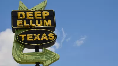
Brandon Formby reports in The Dallas Morning News on a new program lead by the Texas Department of Transportation in partnership with local planners and civic leaders. The goal of the new program called CityMAP is to produce a menu of option for how the city can begin to rebuild, tweak, or replace existing freeways surrounding downtown Dallas to overcome the freeway as a physical barrier that has separated the downtown core from surrounding neighborhoods. An existing example for innovative thinking is the city's Klyde Warren Park, built on a deck over a portion of the Woodall Rodgers Freeway, and opened in 2012. The park has become a popular spot for families and recreationists. However, future transit improvements, including the construction of a high-speed rail station and expansion of the rapid transit system through downtown, have also spurred new thinking for increasing connectivity throughout the city.
"The goal isn’t just to create more deck parks, though more could be in store. There are deeper hopes that updating major infrastructure in the urban core will restitch neighborhoods, spur developments with a dense mix of residences and job centers and give thousands of people the option to ditch their cars altogether."
Three meetings will be held in October and November to get public input on new ideas and potential solutions to create a more integrated downtown core, with the recognition that beyond just a destination, downtown has grown into a thriving live-work community.
FULL STORY: CityMAP planners envision future of downtown Dallas’ aging highways


Dallas City Council to Vote on Controversial Freeway Trenching Plan
A proposal to bury part of Interstate 345 in a 65-foot trench is the latest in a debate that has lasted more than ten years as the freeway reaches the end of its useful life.
Opinion: Hit the Brakes on Dallas Freeway Plan
A proposal to bury a Dallas freeway may not be the best way forward for the area’s residents.
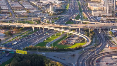
TxDOT Recommends a 10-Lane ‘Infrastructure Grave’ in Dallas
Rather than removing the freeway altogether, which the Texas Department of Transportation calls ‘unfeasible,’ the agency recommends burying the road in a billion-dollar, ten-lane trench through the city’s downtown.

Maui's Vacation Rental Debate Turns Ugly
Verbal attacks, misinformation campaigns and fistfights plague a high-stakes debate to convert thousands of vacation rentals into long-term housing.

Planetizen Federal Action Tracker
A weekly monitor of how Trump’s orders and actions are impacting planners and planning in America.

San Francisco Suspends Traffic Calming Amidst Record Deaths
Citing “a challenging fiscal landscape,” the city will cease the program on the heels of 42 traffic deaths, including 24 pedestrians.

Defunct Pittsburgh Power Plant to Become Residential Tower
A decommissioned steam heat plant will be redeveloped into almost 100 affordable housing units.

Trump Prompts Restructuring of Transportation Research Board in “Unprecedented Overreach”
The TRB has eliminated more than half of its committees including those focused on climate, equity, and cities.

Amtrak Rolls Out New Orleans to Alabama “Mardi Gras” Train
The new service will operate morning and evening departures between Mobile and New Orleans.
Urban Design for Planners 1: Software Tools
This six-course series explores essential urban design concepts using open source software and equips planners with the tools they need to participate fully in the urban design process.
Planning for Universal Design
Learn the tools for implementing Universal Design in planning regulations.
Heyer Gruel & Associates PA
JM Goldson LLC
Custer County Colorado
City of Camden Redevelopment Agency
City of Astoria
Transportation Research & Education Center (TREC) at Portland State University
Jefferson Parish Government
Camden Redevelopment Agency
City of Claremont