


The 82 municipalities that make up Greater Montreal are finally working together to forge a more sustainable, economically robust future.
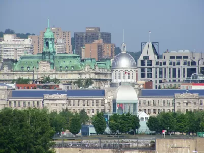
Flavie Halas reports in Citiscope on the ongoing effort in the Montreal metropolitan area to bring the region's 82 municipalities together on shared interests, including better transit, environmental protection, and economic development. After facing crumbling infrastructure, a sluggish economy, and the migration of residents from the urban center to the city's periphery, the region’s mayors developed the Metropolitan Land Use and Development Plan (PMAD), allowing them to address the region's pressing problems together.
"Among the flagship projects included in PMAD is a 'green and blue belt' connecting green space, natural parks, rivers and protected buildings by a network of bike paths, public transit and waterways. That includes a new 143-kilometer (89-mile) bike and pedestrian path going from west to east."
However, the implementation of PMAD’s plans faces continuing challenges, including the sharing of data between municipalities and funding for the new transit infrastructure, which Halas notes has been chronically underfunded. PMAD's success may rely on the continuing cooperation of the region's 82 mayors, who despite occasional differences in opinion have relied on what one mayor describes as a mutual respect and recognition that there must be a balance between the needs of the urban center and the smaller suburban communities surrounding Montreal.
FULL STORY: In the Montréal area, 82 municipalities begin to think and act as one

Book Review: Combining Sustainability and Smart Growth
A review of The Sustainable Urban Design Handbook, by architects Nico Larco and Kaarin Knudson.

Revitalizing Texas: Sustainable Rail Solutions
An argument for why investing in trains is the key to sustainable growth and economic success in the Lone Star State.
Carrots and Sticks: Making Driving Alone the Worst Option
The build out of mass transit and bicycle infrastructure hasn’t been the cure-all for shifting commuters from single-person autos to alternate modes of transit, as many had hoped. Maybe it's time we start looking at how to disincentivize driving.

Maui's Vacation Rental Debate Turns Ugly
Verbal attacks, misinformation campaigns and fistfights plague a high-stakes debate to convert thousands of vacation rentals into long-term housing.

Planetizen Federal Action Tracker
A weekly monitor of how Trump’s orders and actions are impacting planners and planning in America.

In Urban Planning, AI Prompting Could be the New Design Thinking
Creativity has long been key to great urban design. What if we see AI as our new creative partner?

King County Supportive Housing Program Offers Hope for Unhoused Residents
The county is taking a ‘Housing First’ approach that prioritizes getting people into housing, then offering wraparound supportive services.

Researchers Use AI to Get Clearer Picture of US Housing
Analysts are using artificial intelligence to supercharge their research by allowing them to comb through data faster. Though these AI tools can be error prone, they save time and housing researchers are optimistic about the future.

Making Shared Micromobility More Inclusive
Cities and shared mobility system operators can do more to include people with disabilities in planning and operations, per a new report.
Urban Design for Planners 1: Software Tools
This six-course series explores essential urban design concepts using open source software and equips planners with the tools they need to participate fully in the urban design process.
Planning for Universal Design
Learn the tools for implementing Universal Design in planning regulations.
planning NEXT
Appalachian Highlands Housing Partners
Mpact (founded as Rail~Volution)
City of Camden Redevelopment Agency
City of Astoria
City of Portland
City of Laramie