


Many people outside of Salt Lake City might not realize that the city's proximity to the Wasatch Fault puts it at risk for an earthquake likely in the range of 7.1 on the Richter scale.
Henry Grabar reports on the ongoing work of the Utah Geological Survey (UGS) to "to determine the history (and the ongoing potential) of earthquakes in the West Valley fault zone," where Salt Lake City is located. The question they hope to answer: Is Salt Lake City ready for the "Big One."
The "big One" is expected to occur along the Wasatch Fault. "According to a study [pdf] released this summer by the Utah chapter of the Earthquake Engineering Research Institute, “big ones” on the Salt Lake segment of the Wasatch Fault tend to occur every 1,300 to 1,500 years. The last one occurred 1,400 years ago," writes Grabar.
There are also smaller faults just across town, which the UGS is still studying to learn more about their relationship to surrounding faults.
The crux of all this study to those in the planning profession: the research is intended to produce a model of the "degree of ground shaking" in an earthquake. According to Grabar, "Research like this provides the backbone of the municipal codes that dictate how apartments, roadways, transit lines and virtually everything else in the city must be built — or should be renovated."
FULL STORY: Seismologists See Salt Lake City Future Disaster by Reading the Dirt

When the Earth Turns to Liquid
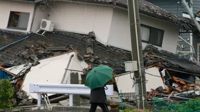
A 7.5 magnitude earthquake struck the Indonesian island of Sulawesi on Sept. 25, followed by a massive tsunami. Soil liquefaction caused by the tremor resulted in 1,700 homes being "swallowed" as the soil shifted. Deaths exceeded 1,400 on Oct. 3.

Bay Area Not Prepared for Next Big One
As the death toll from Mexico's 7.1 magnitude earthquake on Sept. 19 climbs above 300, the San Francisco Chronicle investigates how well prepared the Bay Area is for an earthquake of comparable magnitude. Not very well.
Mexico City Earthquake Should Raise Questions About Building Safety
The epicenter of Tuesday's quake was in the state of Puebla, 80 miles southeast of Mexico City. Soft soil and unreinforced buildings magnified the damage. The quake comes two weeks after an 8.1 quake struck off the coast of the state of Oaxaca.

Planetizen Federal Action Tracker
A weekly monitor of how Trump’s orders and actions are impacting planners and planning in America.

Maui's Vacation Rental Debate Turns Ugly
Verbal attacks, misinformation campaigns and fistfights plague a high-stakes debate to convert thousands of vacation rentals into long-term housing.

San Francisco Suspends Traffic Calming Amidst Record Deaths
Citing “a challenging fiscal landscape,” the city will cease the program on the heels of 42 traffic deaths, including 24 pedestrians.

Defunct Pittsburgh Power Plant to Become Residential Tower
A decommissioned steam heat plant will be redeveloped into almost 100 affordable housing units.

Trump Prompts Restructuring of Transportation Research Board in “Unprecedented Overreach”
The TRB has eliminated more than half of its committees including those focused on climate, equity, and cities.

Amtrak Rolls Out New Orleans to Alabama “Mardi Gras” Train
The new service will operate morning and evening departures between Mobile and New Orleans.
Urban Design for Planners 1: Software Tools
This six-course series explores essential urban design concepts using open source software and equips planners with the tools they need to participate fully in the urban design process.
Planning for Universal Design
Learn the tools for implementing Universal Design in planning regulations.
Heyer Gruel & Associates PA
JM Goldson LLC
Custer County Colorado
City of Camden Redevelopment Agency
City of Astoria
Transportation Research & Education Center (TREC) at Portland State University
Jefferson Parish Government
Camden Redevelopment Agency
City of Claremont