


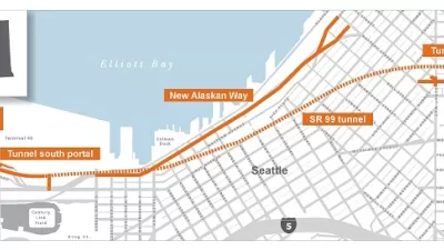
Eventually, Bertha will push through and create an alternative route for what is now Highway 99. Eventually, also, Seattle will decide on a plan to build a park where the viaduct now runs.
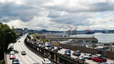
"A battle is brewing over what should be done with a historic piece of Seattle's waterfront," according to an article by Russ Bowen. "It all boils down to a park, but what that park ends up looking like is still very much up for debate."
The controversy pits Park My Viaduct against Waterfront Seattle—each support of separate proposals for a waterfront park, built from the ashes of the doomed Highway 99.
According to Bowen, "Park My Viaduct now has enough signatures to get Initiative 123 on the ballot. It would establish the Downtown Waterfront Preservation and Development Authority that would oversee the construction of the park to replace the viaduct."
"The group has proposed an elevated section that would be a total of six acres. The elevated park would be one mile long and include one section that would be saved from the old viaduct," adds Bowen.
Friends of Waterfront Seattle, however, recently released a statement claiming that Park My Viaduct used paid signature gathers and "appropriated facts and the City's 'Waterfront for All' language." In effect, Friends of Waterfront Seattle prefer the city's project, already underway with environmental review, and say the Park My Viaduct proposal would "put public space into the hands of a private developer."
Mike Lindblom provides additional coverage of the controversy, picking up the news when the Park My Viaduct qualified Initiative 123 for a public vote.
FULL STORY: Battle brewing over Seattle waterfront park proposals

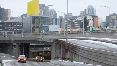
Seattle Emerges From Tolled Tunnel Unscathed
Promises of congestion and thousands of cars spilling on to quiet residential streets proved unfounded after the first week with tolls on the Highway 91 tunnel in Seattle.
Seattle's Most Dramatic Traffic Reduction Will Occur Next Month
There will be no road closures, no traffic bans, no loss of parking, and no new transit lines opening. Call it the "tolling effect" on Nov. 9 when motorists have to pay to drive through the two-mile State Route 99 tunnel that opened last February.
Tax Deal Clears the Way for Seattle's Grand Waterfront Park Plans
A proposed waterfront plan has secured the necessary funding to move forward in Seattle, pending City Council approval.

Maui's Vacation Rental Debate Turns Ugly
Verbal attacks, misinformation campaigns and fistfights plague a high-stakes debate to convert thousands of vacation rentals into long-term housing.

Planetizen Federal Action Tracker
A weekly monitor of how Trump’s orders and actions are impacting planners and planning in America.

Chicago’s Ghost Rails
Just beneath the surface of the modern city lie the remnants of its expansive early 20th-century streetcar system.

Bend, Oregon Zoning Reforms Prioritize Small-Scale Housing
The city altered its zoning code to allow multi-family housing and eliminated parking mandates citywide.

Amtrak Cutting Jobs, Funding to High-Speed Rail
The agency plans to cut 10 percent of its workforce and has confirmed it will not fund new high-speed rail projects.

LA Denies Basic Services to Unhoused Residents
The city has repeatedly failed to respond to requests for trash pickup at encampment sites, and eliminated a program that provided mobile showers and toilets.
Urban Design for Planners 1: Software Tools
This six-course series explores essential urban design concepts using open source software and equips planners with the tools they need to participate fully in the urban design process.
Planning for Universal Design
Learn the tools for implementing Universal Design in planning regulations.
planning NEXT
Appalachian Highlands Housing Partners
Mpact (founded as Rail~Volution)
City of Camden Redevelopment Agency
City of Astoria
City of Portland
City of Laramie