


The 'South Mountain Freeway' would build a 22-mile freeway extension between Laveen and Chandler. The route's proximity to sacred tribal land has prompted a lawsuit, even after years of planning.
The proposed South Mountain Freeway would link Laveen in southwest Phoenix with Chandler by extending Loop 202 for 22 miles. The route would border tribal lands, and despite years of planning and community engagement, still provoked a lawsuit by the Gila River Indian Community. The lawsuit, filed in U.S. District Court on Tuesday [June 30, 2015], contends that state and federal officials failed to 'consider adequately the significant harm the freeway would inflict on the environment and on historical and cultural resources,''" reports Chris Coppola.
South Mountain, which the freeway would cross, is one of the most important and sacred natural resources for the tribal community that lives in the area.
"I get it," writes columnist Joanna Allhands in an op-ed following the news of the lawsuit. "South Mountain Freeway at this point is a joke, a farce, a dream. The weathered sign on Pecos Road denoting the future freeway seems like a monument to bad planning and inaction."
Despite her doubts about the plans for the new freeway, Allhands is still skeptical about the lawsuit's claims that officials did not adequately plan the route during the process of creating a Final Environmental Impact Statement.
Allhands also expresses a willingness to give up on the plans, writing, "maybe, at this point, we should just drop the whole idea and let traffic continue to build on Interstate 10. Or maybe transportation officials should start talking more about building that insane super-freeway extension on I-10 around the Broadway Curve that would create separate lanes for local and regional traffic."
FULL STORY: Gila River tribe sues to prevent South Mountain Freeway

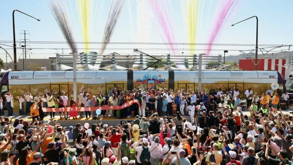
Phoenix Light Rail Extension Opens
The South Central line extends 5.5 miles of rail into South Phoenix neighborhoods, bringing the city’s total light rail network to 35 miles.

Phoenix Announces Opening Date for Light Rail Extension
The South Central extension will connect South Phoenix to downtown and other major hubs starting on June 7.
Phoenix Facilitates School-to-Affordable Housing Development
Two Phoenix school districts are selling their underused properties to build over 200 units of affordable housing.

Maui's Vacation Rental Debate Turns Ugly
Verbal attacks, misinformation campaigns and fistfights plague a high-stakes debate to convert thousands of vacation rentals into long-term housing.

Planetizen Federal Action Tracker
A weekly monitor of how Trump’s orders and actions are impacting planners and planning in America.

In Urban Planning, AI Prompting Could be the New Design Thinking
Creativity has long been key to great urban design. What if we see AI as our new creative partner?

King County Supportive Housing Program Offers Hope for Unhoused Residents
The county is taking a ‘Housing First’ approach that prioritizes getting people into housing, then offering wraparound supportive services.

Researchers Use AI to Get Clearer Picture of US Housing
Analysts are using artificial intelligence to supercharge their research by allowing them to comb through data faster. Though these AI tools can be error prone, they save time and housing researchers are optimistic about the future.

Making Shared Micromobility More Inclusive
Cities and shared mobility system operators can do more to include people with disabilities in planning and operations, per a new report.
Urban Design for Planners 1: Software Tools
This six-course series explores essential urban design concepts using open source software and equips planners with the tools they need to participate fully in the urban design process.
Planning for Universal Design
Learn the tools for implementing Universal Design in planning regulations.
planning NEXT
Appalachian Highlands Housing Partners
Mpact (founded as Rail~Volution)
City of Camden Redevelopment Agency
City of Astoria
City of Portland
City of Laramie