


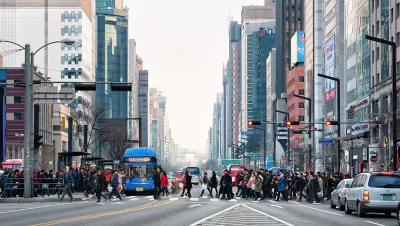
A new article in the Journal of Planning Education and Research tests whether Jacob’s ideas ring true for predicting pedestrian vitality in Seoul.

Jane Jacobs may have written The Life and Death of Great American Cities, thinking of places in the United States like Greenwich Village in Manhattan, the Old North End in Boston, and the "shoe district" in Louisville, but her theories are now influential worldwide. What resonates is the universality of how the built environment contributes to pedestrian vitality. In particular, Jacobs highlighted the importance of diversity in terms of streets, buildings, and people, while offering guidance for good planning in the form of "mixed land uses, small blocks, buildings from many different eras, and sufficient building densities," which allow for vibrant activity throughout the day (Sung et al 2015).
Seoul, South Korea, is characterized by high levels of mixed land uses; its densities are higher than New York City and its transportation network is well developed, but the city is also under constant pressure from centralized redevelopment projects and traffic. A new article in the Journal of Planning Education and Research tests whether Jacob's ideas ring true for predicting pedestrian vitality in Seoul.

Hyungun Sung, Sugie Lee, and SangHyun Cheon test Jacob’s ideas by comparing the volume and composition of pedestrian and automobile trips in Seoul at different times of the day. The authors used Korean neighborhood units ("dongs"), which are approximately the same size as Jacob's ideal urban district. They developed several measures of land use mix and included other characteristics of the neighborhoods, such as the age of buildings, density, block size, and border vacuums (e.g., large obstacles, like highways or superblocks, which interrupt the street grid) in their analysis.

They found that short blocks, arranged in networks with four way intersections, promote pedestrian uses, and border vacuums harm the pedestrian environment. To test Jacob's hypothesis that vibrant districts also have activity through the day, the authors evaluated how various neighborhood characteristics contributed to having sustained pedestrian activity at different times. The evidence for this was mixed, as many areas within Seoul are 24-hour districts.

This paper largely confirms Jacob's theory of urban vitality as related to environments that promote pedestrian oriented communities. These results are consistent with the 5-Ds described by Robert Cervero (Density, Diversity, Design, Destination, and Distance to Transit), and confirmed in other empirical research of developments based on these principles, such as LEED-ND (Ewing et al 2013). That is to say that people in Korea respond to the built environment much in the same way as people in the United States.
Seoul or New York are certainly not examples for every community, but these results may also remind planners that fixtures of American development practices and regulation, such as, single-use zoning, superblocks linked by arterials, street design, and subdivision ordinances that discourage connectivity and suppress density may be insurmountable barriers to vibrant street life.

The authors of the paper are, respectively, from Chungbuk University, Cheongju, Korea, Hanyang University, Seoul, Korea, and HongIk University, Seoul, Korea.


How the ‘Social Field of View’ Impacts Street Life
The vibrancy of a neighborhood may be defined by what people can see in their immediate vicinity.

Ambulances vs. Pedestrians
Are the needs of emergency response vehicles inconsistent with nondrivers’ needs for slower, safer streets? Maybe not.
Midtown Atlanta Plaza Replaces Parking With Public Seating, Art
The formerly car-centric block was redesigned to include wider sidewalks, public seating, and enhanced landscaping in lieu of on-street parking.

Planetizen Federal Action Tracker
A weekly monitor of how Trump’s orders and actions are impacting planners and planning in America.

Maui's Vacation Rental Debate Turns Ugly
Verbal attacks, misinformation campaigns and fistfights plague a high-stakes debate to convert thousands of vacation rentals into long-term housing.

San Francisco Suspends Traffic Calming Amidst Record Deaths
Citing “a challenging fiscal landscape,” the city will cease the program on the heels of 42 traffic deaths, including 24 pedestrians.

Amtrak Rolls Out New Orleans to Alabama “Mardi Gras” Train
The new service will operate morning and evening departures between Mobile and New Orleans.

The Subversive Car-Free Guide to Trump's Great American Road Trip
Car-free ways to access Chicagoland’s best tourist attractions.

San Antonio and Austin are Fusing Into one Massive Megaregion
The region spanning the two central Texas cities is growing fast, posing challenges for local infrastructure and water supplies.
Urban Design for Planners 1: Software Tools
This six-course series explores essential urban design concepts using open source software and equips planners with the tools they need to participate fully in the urban design process.
Planning for Universal Design
Learn the tools for implementing Universal Design in planning regulations.
Heyer Gruel & Associates PA
JM Goldson LLC
Custer County Colorado
City of Camden Redevelopment Agency
City of Astoria
Transportation Research & Education Center (TREC) at Portland State University
Jefferson Parish Government
Camden Redevelopment Agency
City of Claremont