


Developers get a lot of milage from building privately owned public spaces—but the public often doesn't. Planners in San Francisco are now requiring buildings to make hidden POPS known, so that the public can actually use them.
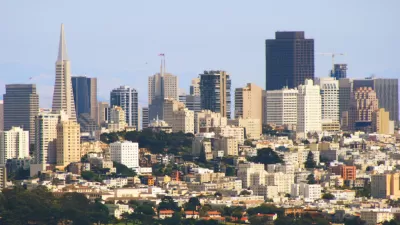
Many a development agreement has been sweetened by the inclusion of privately owned public spaces (POPS), which are intended to provide community benefits at developers' expense. POPSs can include plazas, paseos, seating areas, sculpture gardens and the like, all of which are supposed to be accessible to and enjoyed by the public. In San Francisco, one square foot of POPS is required for every 50 square feet of new commercial space.
Years of research indicates, however, that POPS's are rarely used, in part because they are often hidden or, as San Francisco Chronicle architecture critic John King puts it, "cynically discreet." They become dead spaces even as developers reap the benefits.
The city of San Francisco is trying to reverse this trend by requiring landlords to post signs and otherwise make POPS more visible. Planners will also be making sure that the POPS that developers have built actually match up with those that were promised.
“A key element of the city’s downtown plan is that we need publicly accessible spaces that are easy to find and that people can enjoy,” said Scott Sanchez, the City Planning Department’s zoning administrator. “If you don’t know they’re there, you won’t use them.”
FULL STORY: S.F. making sure high-rise owners ID hidden public spaces

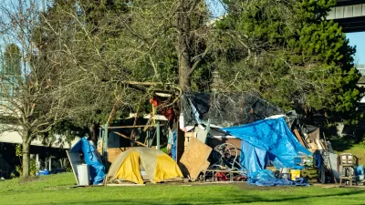
Tent Encampments: Will the Legal Restraint be Lifted?
A controversial U.S. Ninth Circuit Court of Appeals ruling in 2018 that has hindered the ability of western cities to clear tent encampments on public spaces will likely be revisited and overturned by the Supreme Court, predicts a popular CNN host.
A Bold Vision for a Car-Free Boston
As other cities take daring steps to reclaim their streets, a car ban in downtown Boston doesn’t seem so implausible.

Making Privately Owned Public Spaces in New York City More Accessible by Mapping Them
A new map shows where privately owned public spaces are located to encourage more public use.

Maui's Vacation Rental Debate Turns Ugly
Verbal attacks, misinformation campaigns and fistfights plague a high-stakes debate to convert thousands of vacation rentals into long-term housing.

Planetizen Federal Action Tracker
A weekly monitor of how Trump’s orders and actions are impacting planners and planning in America.

In Urban Planning, AI Prompting Could be the New Design Thinking
Creativity has long been key to great urban design. What if we see AI as our new creative partner?

Cal Fire Chatbot Fails to Answer Basic Questions
An AI chatbot designed to provide information about wildfires can’t answer questions about evacuation orders, among other problems.

What Happens if Trump Kills Section 8?
The Trump admin aims to slash federal rental aid by nearly half and shift distribution to states. Experts warn this could spike homelessness and destabilize communities nationwide.

Sean Duffy Targets Rainbow Crosswalks in Road Safety Efforts
Despite evidence that colorful crosswalks actually improve intersection safety — and the lack of almost any crosswalks at all on the nation’s most dangerous arterial roads — U.S. Transportation Secretary Duffy is calling on states to remove them.
Urban Design for Planners 1: Software Tools
This six-course series explores essential urban design concepts using open source software and equips planners with the tools they need to participate fully in the urban design process.
Planning for Universal Design
Learn the tools for implementing Universal Design in planning regulations.
Appalachian Highlands Housing Partners
Gallatin County Department of Planning & Community Development
Heyer Gruel & Associates PA
Mpact (founded as Rail~Volution)
City of Camden Redevelopment Agency
City of Astoria
City of Portland
City of Laramie