


A new report from City Observatory analyzes urban poverty and gentrification using census data from 1970 to 2010.
As Joe Cortright writes in Next City, City Observatory has created a new report analyzing the relationship between urban poverty and gentrification in American cities from 1970 to 2010. Specifically, the organization asked the question, “how many neighborhoods that used to have high rates of poverty have actually gentrified and how many people have actually been displaced by this new development?”
The results are found in the report titled, "Lost in Place: Why the persistence and spread of concentrated poverty–not gentrification–is our biggest urban challenge." Cortright summarizes some of the surprising findings, like how the hyper-gentrification of Williamsburg, for example, is rare throughout the country, as “[l]ess than 5 percent of 1970 high poverty neighborhoods have seen their poverty rates fall to below the national average over the past four decades. Far more common, and largely unnoticed, is a counter trend: the number of high-poverty neighborhoods in the U.S. has tripled, and the number of poor persons living in them has doubled since 1970. This growing concentration of poverty is the biggest problem confronting American cities.”
Cortright presents other findings from the report in his piece, like the deepening concentrations of poverty in neighborhoods and their population instability.
FULL STORY: More People in Cities Today Live in Poverty Than in 1970

Inclusive Prosperity: No Displacement Necessary
Recent analysis identifies nearly 200 U.S. neighborhoods that have achieved the highly-sought-after goal of increasing the prosperity of residents without displacing the existing community.
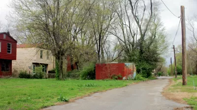
Poverty Concentrating in Already High-Poverty Neighborhoods
A pair of reports analyzing U.S. Census Bureau poverty data from the last two decades show that high-poverty neighborhoods have become further impoverished.
More Evidence that Decline and Concentrated Poverty Define the Urban Experience
Concern about gentrification in urban areas has dominated the urbanism discussion for more than a decade now, at the expense of a more informed understanding of urban dynamics and the potential for more effective action.

Maui's Vacation Rental Debate Turns Ugly
Verbal attacks, misinformation campaigns and fistfights plague a high-stakes debate to convert thousands of vacation rentals into long-term housing.

Planetizen Federal Action Tracker
A weekly monitor of how Trump’s orders and actions are impacting planners and planning in America.

San Francisco Suspends Traffic Calming Amidst Record Deaths
Citing “a challenging fiscal landscape,” the city will cease the program on the heels of 42 traffic deaths, including 24 pedestrians.

Defunct Pittsburgh Power Plant to Become Residential Tower
A decommissioned steam heat plant will be redeveloped into almost 100 affordable housing units.

Trump Prompts Restructuring of Transportation Research Board in “Unprecedented Overreach”
The TRB has eliminated more than half of its committees including those focused on climate, equity, and cities.

Amtrak Rolls Out New Orleans to Alabama “Mardi Gras” Train
The new service will operate morning and evening departures between Mobile and New Orleans.
Urban Design for Planners 1: Software Tools
This six-course series explores essential urban design concepts using open source software and equips planners with the tools they need to participate fully in the urban design process.
Planning for Universal Design
Learn the tools for implementing Universal Design in planning regulations.
Heyer Gruel & Associates PA
JM Goldson LLC
Custer County Colorado
City of Camden Redevelopment Agency
City of Astoria
Transportation Research & Education Center (TREC) at Portland State University
Jefferson Parish Government
Camden Redevelopment Agency
City of Claremont