


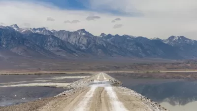
After years of feud between Los Angeles and the Great Basin Unified Air Pollution Control District, a more sustainable deal has been reached to eradicate the toxic dust storms plaguing Owens Valley.
Ever since the early 1900s, Los Angeles has been trying to find water to quench the thirst of the growing metropolis. In 1913, Owens Lake, a now-dry lake between the Sierra Nevada and Inyo Mountains, was the source of Los Angeles' early aqueduct to supply water. That only lasted until the mid-1920's, when the lake dried up and began causing toxic dust storms in the region.
According to a Los Angeles Times article by Louis Sahagun, for years due to liability from the Clean Air Act, the Los Angeles Department of Water and Power, "has flooded most of the 110-square-mile lake bed to prevent choking dust storms in the valley that left residents suffering from asthma and other respiratory ailments."
Now, the new method uses "tractors to turn moist lake bed clay into furrows and basketball-sized clods of dirt. The clods will bottle up the dust for years before breaking down, at which point the process will be repeated. The method was first tested in the early 1990s, then tabled out of concern the furrows and clods would disintegrate after a few rains. Two years ago, the DWP resurrected the idea and tested it on several acres of lake bed, but on a much larger scale, with furrows 2 to 3 feet deep. The results showed promise, provided the treated area has clay soil and flooding infrastructure in place."
The new method will go in place in December this year and save about three billion gallons of water in the first year and ten billion gallons three years after that. In addition, this new method will only cost "DWP customers about $1 million per square mile — three times less than shallow flooding. The cost of reducing dust with gravel, which has been applied to swaths of the lake bed, is about $25 million per square mile, officials said."
FULL STORY: New dust-busting method ends L.A.'s longtime feud with Owens Valley

California Braces for Floods After Historic Winter Storms
Emerging from a years-long drought, the state now faces significant flood risks as temperatures rise and the abundant snowpack begins to melt.

L.A.’s Water Diversions Threaten Critical Habitat Far to the North
Water levels at Mono Lake, nestled in a stunningly beautiful location on the eastern slope of the Sierra Nevadas that provides the eastern gateway to Yosemite, have fallen to a critical level of a local population of nesting gulls.
Southern California's Water Conservation and Storage Efforts Paying Off
The region has poured over a billion dollars into storage infrastructure and demand management policies in anticipation of worsening drought conditions.

Maui's Vacation Rental Debate Turns Ugly
Verbal attacks, misinformation campaigns and fistfights plague a high-stakes debate to convert thousands of vacation rentals into long-term housing.

Planetizen Federal Action Tracker
A weekly monitor of how Trump’s orders and actions are impacting planners and planning in America.

In Urban Planning, AI Prompting Could be the New Design Thinking
Creativity has long been key to great urban design. What if we see AI as our new creative partner?

Cal Fire Chatbot Fails to Answer Basic Questions
An AI chatbot designed to provide information about wildfires can’t answer questions about evacuation orders, among other problems.

What Happens if Trump Kills Section 8?
The Trump admin aims to slash federal rental aid by nearly half and shift distribution to states. Experts warn this could spike homelessness and destabilize communities nationwide.

Sean Duffy Targets Rainbow Crosswalks in Road Safety Efforts
Despite evidence that colorful crosswalks actually improve intersection safety — and the lack of almost any crosswalks at all on the nation’s most dangerous arterial roads — U.S. Transportation Secretary Duffy is calling on states to remove them.
Urban Design for Planners 1: Software Tools
This six-course series explores essential urban design concepts using open source software and equips planners with the tools they need to participate fully in the urban design process.
Planning for Universal Design
Learn the tools for implementing Universal Design in planning regulations.
Appalachian Highlands Housing Partners
Gallatin County Department of Planning & Community Development
Heyer Gruel & Associates PA
Mpact (founded as Rail~Volution)
City of Camden Redevelopment Agency
City of Astoria
City of Portland
City of Laramie