


Emerging from a half century of dictatorship, can Myanmar's principal city be a model of sustainable, democratic development?
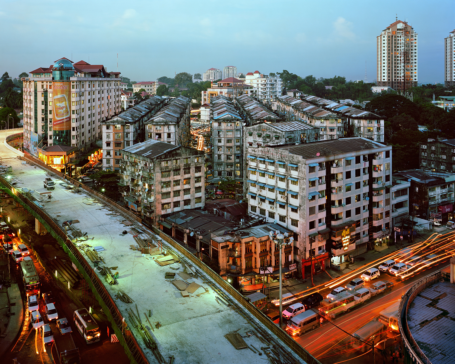
[Photo by Andrew Rowat]
The newly revamped Places Journal has published the first installment in a new series, "History of the Present," featuring in-depth articles on cities undergoing profound transition. The first article is by journalist Daniel Brook, author of A History of Future Cities (one of Planetizen's Top 10 Books of 2014).
Brook reports on urban development in Yangon, Myanmar, where planners, developers, activists, and government cronies vie for the right to define the city’s future after decades of military dictatorship:
"Time and again, I spotted signs marking construction zones. Coming soon: a guesthouse; coming soon: a bank; coming soon: a hotel. It might as well have been the city’s official slogan. Yangon: coming soon. In the historic heart of the city, the Secretariat Building, the colonial seat of British Burma, sat abandoned and fenced off behind barbed wire, foliage growing out of its roof. Known as the Ministers’ Office since independence, the massive red-brick pile was left to ruin in 2006 when the military regime that has ruled the country for decades packed up and moved to a new capital city. Now, locals debated what it would become. Surely, something was coming soon."
Among the article's many illuminating moments is an interview with Toe Aung, the chief planner for Yangon, who until recently was an army major with no urban planning experience. Brook also speaks with the developer of the first gated community in the country and with the activists who are trying to preserve Yangon's historic architecture and public spaces.
In a letter published last week, Places editor Nancy Levinson announced that after five years in partnership with Design Observer, Places has launched a new, independent website, "reaffirming our commitment to rigorous and lively public scholarship on architecture, landscape, and urbanism."
FULL STORY: History of the Present: Yangon


In Urban Planning, AI Prompting Could be the New Design Thinking
Creativity has long been key to great urban design. What if we see AI as our new creative partner?
May Must-Reads: Top 10 Articles From Last Month
Mall redevelopment, saving California’s high-speed rail, and a provocative rethinking of the concept of redlining.

Four Reasons Urban Planners Can’t Ignore AI
It’s no longer a question of whether AI will shape planning, but how. That how is up to us.

Maui's Vacation Rental Debate Turns Ugly
Verbal attacks, misinformation campaigns and fistfights plague a high-stakes debate to convert thousands of vacation rentals into long-term housing.

Planetizen Federal Action Tracker
A weekly monitor of how Trump’s orders and actions are impacting planners and planning in America.
In Urban Planning, AI Prompting Could be the New Design Thinking
Creativity has long been key to great urban design. What if we see AI as our new creative partner?

Portland Raises Parking Fees to Pay for Street Maintenance
The city is struggling to bridge a massive budget gap at the Bureau of Transportation, which largely depleted its reserves during the Civd-19 pandemic.

Spokane Mayor Introduces Housing Reforms Package
Mayor Lisa Brown’s proposals include deferring or waiving some development fees to encourage more affordable housing development.

Houston Mayor Kills Another Bike Lane
The mayor rejected a proposed bike lane in the Montrose district in keeping with his pledge to maintain car lanes.
Urban Design for Planners 1: Software Tools
This six-course series explores essential urban design concepts using open source software and equips planners with the tools they need to participate fully in the urban design process.
Planning for Universal Design
Learn the tools for implementing Universal Design in planning regulations.
Gallatin County Department of Planning & Community Development
Heyer Gruel & Associates PA
JM Goldson LLC
City of Camden Redevelopment Agency
City of Astoria
Transportation Research & Education Center (TREC) at Portland State University
Jefferson Parish Government
Camden Redevelopment Agency
City of Claremont