


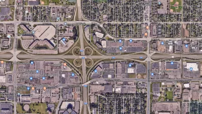
A writer laments the lack of return on investment reflected by a state DOT's decision to fund a highway-widening project for $20 million that will serve 1,100 daily car trips.
"MNDOT recently announced that it will be spending roughly 20 million to fix up Highway 66 which connects Good Thunder with Mankato." The problem with that plan, according to Matthias Leyrer, is that the choice to invest that much public money in this particular project is that it's a lot of money to spend on a very small amount of people, who may or may not even want the "improvements."
"The AADT (Average Annual Daily Traffic) for this road is 1,100 cars. Roughly double the residency of Good Thunder or essentially every citizen coming to and from Mankato every day. If you want, think about it as $20,000 per car. Oh, did I mention that the road is about 12 miles long? So yet another way of thinking about it is roughly $1.6m a mile."
"Furthermore, a lot of people don’t even want the road to change to the degree the state has in mind. The state wants to widen it, make it straighter and design it for higher speeds. When they told this to the county, most of the residents along the road said 'screw that!'"
Leyrer summarizes his frustration with the project and its implications about transportation planning: "We have a problem in this country of upgrading, fixing or building infrastructure even if it’s ROI is little or nothing. We then have to maintain this infrastructure which has huge financial implications on our city, state and national budgets."
FULL STORY: How to Blow $20,000,000 on 1,100 People

Nine Highway Expansions Identified as Worst Boondoggles of 2018
In a new report, U.S. PIRG and the Frontier Group describe nine costly highway projects amounting to $30 billion in their fourth annual "Highway Boondoggles" report. All share the theme of induced travel demand.
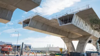
PIRG Releases Third Highway Boondoggles Report
A new report from the U.S. Public Interest Research Group and the Frontier Group indicates that highway boondoggles have been getting bigger, more costly, with the benefits more limited. Nine projects are analyzed in "Highway Boondoggles 3."
Report Identifies 12 'Highway Boondoggles'
A new report by U.S. PIRG and the Frontier Group identifies the highway projects most likely to break the transportation funding bank.

Maui's Vacation Rental Debate Turns Ugly
Verbal attacks, misinformation campaigns and fistfights plague a high-stakes debate to convert thousands of vacation rentals into long-term housing.

Planetizen Federal Action Tracker
A weekly monitor of how Trump’s orders and actions are impacting planners and planning in America.

In Urban Planning, AI Prompting Could be the New Design Thinking
Creativity has long been key to great urban design. What if we see AI as our new creative partner?

King County Supportive Housing Program Offers Hope for Unhoused Residents
The county is taking a ‘Housing First’ approach that prioritizes getting people into housing, then offering wraparound supportive services.

Researchers Use AI to Get Clearer Picture of US Housing
Analysts are using artificial intelligence to supercharge their research by allowing them to comb through data faster. Though these AI tools can be error prone, they save time and housing researchers are optimistic about the future.

Making Shared Micromobility More Inclusive
Cities and shared mobility system operators can do more to include people with disabilities in planning and operations, per a new report.
Urban Design for Planners 1: Software Tools
This six-course series explores essential urban design concepts using open source software and equips planners with the tools they need to participate fully in the urban design process.
Planning for Universal Design
Learn the tools for implementing Universal Design in planning regulations.
planning NEXT
Appalachian Highlands Housing Partners
Mpact (founded as Rail~Volution)
City of Camden Redevelopment Agency
City of Astoria
City of Portland
City of Laramie