


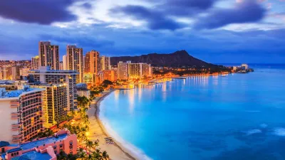
Using a metric called "regional price parity," the Commerce Department's Bureau of Economic Analysis shows that urban areas are the most expensive places in the country. Honolulu, Hawaii rates as the most expensive metro area in the country.
"[Urban] Honolulu takes the prize as the most expensive metro area in the nation," according to analysis by Danielle Kurtzleben of figures recently released by the Commerce Department's Bureau of Economic Analysis. The recent figures measure "regional price parity," which provides a holistic picture of the costs associated with living in any given place in the country.
Kurtzleben's analysis, complete with maps and graphs, includes analysis of states and metro areas.
As for states: "DC had the highest prices in the nation as of 2012, with a regional price parity score of 118.2. That means its prices were 18.2 percent higher than the national price level in 2012. It is followed by Hawaii (117.2) and New York (115.4)."
And for metro areas, here's some of why Honolulu rates as the most expensive in the country: "Hawaii tends to have higher food prices than other states, for example, because so much of the food Hawaiians consume has to be shipped across the ocean. In addition, some have called the amount of money people are willing to pay to live in Hawaii "the price of paradise" — a book of that title penned 20 years ago discussed this problem, and the state has remained expensive since then."
FULL STORY: Honolulu is even more expensive than New York or San Francisco


Expanding Access to Design Education at Honolulu Community College
Honolulu Community College’s Architecture, Engineering & Construction Technologies program highlights the role of community colleges in preparing nontraditional students for careers in architectural and construction technologies.

Honolulu Community College Celebrates Culture and Sustainability
Honolulu Community College brought together more than 320 students, staff, and community members for a day of Hawaiian cultural activities, music, and sustainability-focused learning at its annual Hoʻolauleʻa celebration.
Honolulu's Iwilei Center Plans for Redevelopment Into Mixed-Use Space
Striving to expand affordable housing options for Oahu residents, Honolulu's Department of Land Management requests to redevelop the Iwilei Center into a mixed-use space.

Maui's Vacation Rental Debate Turns Ugly
Verbal attacks, misinformation campaigns and fistfights plague a high-stakes debate to convert thousands of vacation rentals into long-term housing.

Planetizen Federal Action Tracker
A weekly monitor of how Trump’s orders and actions are impacting planners and planning in America.

San Francisco Suspends Traffic Calming Amidst Record Deaths
Citing “a challenging fiscal landscape,” the city will cease the program on the heels of 42 traffic deaths, including 24 pedestrians.

Defunct Pittsburgh Power Plant to Become Residential Tower
A decommissioned steam heat plant will be redeveloped into almost 100 affordable housing units.

Trump Prompts Restructuring of Transportation Research Board in “Unprecedented Overreach”
The TRB has eliminated more than half of its committees including those focused on climate, equity, and cities.

Amtrak Rolls Out New Orleans to Alabama “Mardi Gras” Train
The new service will operate morning and evening departures between Mobile and New Orleans.
Urban Design for Planners 1: Software Tools
This six-course series explores essential urban design concepts using open source software and equips planners with the tools they need to participate fully in the urban design process.
Planning for Universal Design
Learn the tools for implementing Universal Design in planning regulations.
Heyer Gruel & Associates PA
JM Goldson LLC
Custer County Colorado
City of Camden Redevelopment Agency
City of Astoria
Transportation Research & Education Center (TREC) at Portland State University
Jefferson Parish Government
Camden Redevelopment Agency
City of Claremont