


Rome's new mayor spent two decades in Philadelphia and Pittsburgh, and he's bringing lessons learned while living car-free in the United States to help solve Rome's traffic problems.
Ignazio Marino was a "distinctive sight" commuting to and from his his job as a transplant surgeon at Thomas Jefferson University Hospital in Philadelphia via red Schwinn. "Even though Marino spent his formative years in cities whose narrow streets encourage walking - Genoa as a child, Rome for medical school - he said it wasn't until he moved to Philadelphia in 2003 that he lived in a city without owning a car," writes Inga Saffron.
When he began campaigning to become the mayor of Rome on promises to "make the car-choked Italian capital a more livable place," it was those experiences in Philadelphia that informed his agenda.
"Unlike Parisians, who have taken to their Velib bike-share system with a vengeance, or Londoners, who have pedestrianized part of Trafalgar Square, he felt Romans had been slow to adopt planning ideas that favor walkers and bicyclists - even though they practically invented the gracious pedestrian plaza."
After closing one central Roman road to nonessential traffic on weekdays and all motorized vehicles on weekends, Marino is looking to add more car-free zones, launch a bike-share program, and expand the city's network of bike lanes.
FULL STORY: Changing Skyline: Former Philadelphian transforms Roman traffic

With Pedestrianization Plan, the Eternal City Looks to Ban a Modern Scourge
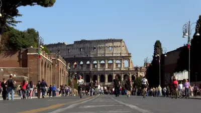
Mayor Ignazio Marino of Rome has banned private vehicles from Via dei Fori Imperiali, built by Benito Mussolini to link his palace in Piazza Venezia to the Colosseum. Initially open to buses and taxis, it will eventually be completely pedestrianized.

Video: A ‘European-Style’ Street in Philadelphia
With its narrow lanes and mature trees, Philadelphia’s Quince Street illustrates what’s possible.
Rick Steves on Walkability Lessons From Europe
Many of Europe’s pedestrian-friendly, transit-rich cities weren’t always that way.

Maui's Vacation Rental Debate Turns Ugly
Verbal attacks, misinformation campaigns and fistfights plague a high-stakes debate to convert thousands of vacation rentals into long-term housing.

Planetizen Federal Action Tracker
A weekly monitor of how Trump’s orders and actions are impacting planners and planning in America.

San Francisco Suspends Traffic Calming Amidst Record Deaths
Citing “a challenging fiscal landscape,” the city will cease the program on the heels of 42 traffic deaths, including 24 pedestrians.

Defunct Pittsburgh Power Plant to Become Residential Tower
A decommissioned steam heat plant will be redeveloped into almost 100 affordable housing units.

Trump Prompts Restructuring of Transportation Research Board in “Unprecedented Overreach”
The TRB has eliminated more than half of its committees including those focused on climate, equity, and cities.

Amtrak Rolls Out New Orleans to Alabama “Mardi Gras” Train
The new service will operate morning and evening departures between Mobile and New Orleans.
Urban Design for Planners 1: Software Tools
This six-course series explores essential urban design concepts using open source software and equips planners with the tools they need to participate fully in the urban design process.
Planning for Universal Design
Learn the tools for implementing Universal Design in planning regulations.
Heyer Gruel & Associates PA
JM Goldson LLC
Custer County Colorado
City of Camden Redevelopment Agency
City of Astoria
Transportation Research & Education Center (TREC) at Portland State University
Jefferson Parish Government
Camden Redevelopment Agency
City of Claremont