


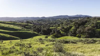
Originally intended for permanent farmland and open space, Davis, CA will consider whether 391 acres along its eastern edge should instead be used for a business technology park, reports Mark Anderson.
Three years ago, the City of Davis bought 391 acres of land with the intention of permanently conserving it as open space. Known as “Mace Curve” and “Leland Ranch”, the property is located on the city's eastern edge. Almost 75% percent of it is prime farmland.
The city partnered with the Yolo Land Trust to apply for a Natural Resources Conservation Services grant to put the land into a conservation easement, which is still in progress. However, before the process is complete, the City Council voted to explore other possible uses for the land, including a business technology park.
The site is one of the last large pieces of land left in the city, and business leaders want more space to grow. “This is not ‘build it and they will come,’” Councilwoman Rochelle Swanson said. “This is ‘build it or they will leave.’”
FULL STORY: Davis Explores Options for Mace Boulevard Farmland


Innovative Park Agencies Receive National Recognition
The National Recreation and Park Association (NRPA) recently announced the recipients of this year’s awards for innovation in health and wellness, equity, conservation, and park design.
Regenerating and Healing Land Through Parks
Through thoughtful planning and restoration efforts, parks can help heal degraded land, meeting multiple community needs, improving soil quality, restoring native vegetation, and creating habitats for wildlife.
Maine Law Promotes Smart Growth
New state legislation encourages cities to plan around ‘smart growth’ principles to preserve farmland and open space, and use infill development to build more housing.

Maui's Vacation Rental Debate Turns Ugly
Verbal attacks, misinformation campaigns and fistfights plague a high-stakes debate to convert thousands of vacation rentals into long-term housing.

Planetizen Federal Action Tracker
A weekly monitor of how Trump’s orders and actions are impacting planners and planning in America.

In Urban Planning, AI Prompting Could be the New Design Thinking
Creativity has long been key to great urban design. What if we see AI as our new creative partner?

Portland Raises Parking Fees to Pay for Street Maintenance
The city is struggling to bridge a massive budget gap at the Bureau of Transportation, which largely depleted its reserves during the Civd-19 pandemic.

Spokane Mayor Introduces Housing Reforms Package
Mayor Lisa Brown’s proposals include deferring or waiving some development fees to encourage more affordable housing development.

Houston Mayor Kills Another Bike Lane
The mayor rejected a proposed bike lane in the Montrose district in keeping with his pledge to maintain car lanes.
Urban Design for Planners 1: Software Tools
This six-course series explores essential urban design concepts using open source software and equips planners with the tools they need to participate fully in the urban design process.
Planning for Universal Design
Learn the tools for implementing Universal Design in planning regulations.
Gallatin County Department of Planning & Community Development
Heyer Gruel & Associates PA
JM Goldson LLC
City of Camden Redevelopment Agency
City of Astoria
Transportation Research & Education Center (TREC) at Portland State University
Jefferson Parish Government
Camden Redevelopment Agency
City of Claremont