


The creator of a lauded guerrilla wayfinding project for Raleigh has launched a new website that allows users to duplicate his compelling signage for their communities.
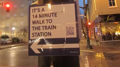
Last year, graduate student Matt Tomasulo launched a guerrilla wayfinding project in Raleigh, North Carolina that was so successful city leaders decided to adopt his idea. With the launch of Walk [Your City], you too can try your hand at getting your neighbors, and visitors, moving.
"The website is built around a handy tool that allows everyone to create custom street signs based on walkability," explains Stijn Hupkes. "Users draw a route between two points and the tool automatically calculates the walk or cycle minutes from A to B, as well as generates a good-looking sign. A QR code in the bottom corner links to a mobile website that displays the entire walking route."
"With the launch of the Walk [Your City] website, Tomasulo gives the rest of the world the opportunity to add a user-generated layer of wayfinding to cities."
FULL STORY: DIY Wayfinding Helps Growing Community Sense

City Puts an End to Guerrilla "Walk Raleigh" Campaign
A widely publicized guerrilla wayfinding campaign meant to give helpful guidance and encouragement to those exploring the city of Raleigh on foot has been quashed by the City Planning Director, report Chelsea Kellner and Bruce Siceloff.
The Vast Potential of the Right-of-Way
One writer argues that the space between two building faces is the most important element of the built environment.

Opinion: What San Francisco’s Proposed ‘Family Zoning’ Could Really Mean
Mayor Lurie is using ‘family zoning’ to encourage denser development and upzoning — but could the concept actually foster community and more human-scale public spaces?

Maui's Vacation Rental Debate Turns Ugly
Verbal attacks, misinformation campaigns and fistfights plague a high-stakes debate to convert thousands of vacation rentals into long-term housing.

Planetizen Federal Action Tracker
A weekly monitor of how Trump’s orders and actions are impacting planners and planning in America.

In Urban Planning, AI Prompting Could be the New Design Thinking
Creativity has long been key to great urban design. What if we see AI as our new creative partner?

King County Supportive Housing Program Offers Hope for Unhoused Residents
The county is taking a ‘Housing First’ approach that prioritizes getting people into housing, then offering wraparound supportive services.

Researchers Use AI to Get Clearer Picture of US Housing
Analysts are using artificial intelligence to supercharge their research by allowing them to comb through data faster. Though these AI tools can be error prone, they save time and housing researchers are optimistic about the future.

Making Shared Micromobility More Inclusive
Cities and shared mobility system operators can do more to include people with disabilities in planning and operations, per a new report.
Urban Design for Planners 1: Software Tools
This six-course series explores essential urban design concepts using open source software and equips planners with the tools they need to participate fully in the urban design process.
Planning for Universal Design
Learn the tools for implementing Universal Design in planning regulations.
planning NEXT
Appalachian Highlands Housing Partners
Mpact (founded as Rail~Volution)
City of Camden Redevelopment Agency
City of Astoria
City of Portland
City of Laramie