


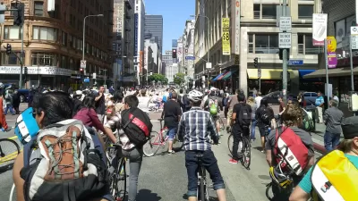
Sunday saw the sixth incarnation of L.A.'s popular CicLAvia event, which closes long stretches of city streets to automobile traffic, and opens them to bikes and pedestrians. The latest route, from downtown to the sea, attracted 150,000 people.

Modeled on Ciclovia, a 30-year-old open streets event held in Bogota, Colombia, CicLAvia provides an opportunity for Angelenos to share in the city's burgeoning bicycle culture, see their city in a different way, and appreciate the variety of modes who seek to utilize the city's streets.
After five successful events held over the last three years in central Los Angeles, last weekend's event was the first in which street closures extended all the way to the ocean. And a record crowd estimated at 150,000 took advantage of the closure of Venice Boulevard, "a streetcar route in the bygone era of Los Angeles' Red Cars."
"With an eye on his legacy in the waning days of his eight years in office, Mayor Antonio Villaraigosa described the event as emblematic of a city reducing its reliance on the automobile, with 148 miles of new bike lanes and a rapidly expanding network of rail lines," say Michael Finnegan, Samantha Schaefer and Abby Sewell.
"It's not a walkable city yet, but it's becoming a walkable city," said Villaraigosa.
FULL STORY: Non-drivers hog the road at 6th and biggest CicLAvia


LA Metro Could Slash Open Streets Funding
Despite the program’s success across the region and rising production costs, Los Angeles-area events could receive less funding in the coming year.

CicLAvia Helping Restaurants Keep Outdoor Dining
CicLAvia is working with the city to make its "al fresco dining" program permanent.
CicLAvia: Reclaiming Streets in the Car Capital of America
The second in a series profiling grassroots activism to increase biking among the diverse populations of Los Angeles County. In this installment, Planetizen spoke with Robert Gard, director of communications for CicLAvia.

Maui's Vacation Rental Debate Turns Ugly
Verbal attacks, misinformation campaigns and fistfights plague a high-stakes debate to convert thousands of vacation rentals into long-term housing.

Planetizen Federal Action Tracker
A weekly monitor of how Trump’s orders and actions are impacting planners and planning in America.

Chicago’s Ghost Rails
Just beneath the surface of the modern city lie the remnants of its expansive early 20th-century streetcar system.

Bend, Oregon Zoning Reforms Prioritize Small-Scale Housing
The city altered its zoning code to allow multi-family housing and eliminated parking mandates citywide.

Amtrak Cutting Jobs, Funding to High-Speed Rail
The agency plans to cut 10 percent of its workforce and has confirmed it will not fund new high-speed rail projects.

LA Denies Basic Services to Unhoused Residents
The city has repeatedly failed to respond to requests for trash pickup at encampment sites, and eliminated a program that provided mobile showers and toilets.
Urban Design for Planners 1: Software Tools
This six-course series explores essential urban design concepts using open source software and equips planners with the tools they need to participate fully in the urban design process.
Planning for Universal Design
Learn the tools for implementing Universal Design in planning regulations.
planning NEXT
Appalachian Highlands Housing Partners
Mpact (founded as Rail~Volution)
City of Camden Redevelopment Agency
City of Astoria
City of Portland
City of Laramie