


BuzzFeed has gathered 38 prime examples of "maps you never knew you needed." And while some are fascinating (such as how much space the world's population would take up if everyone lived in one city) others are just Ludacris.
Ever wonder what time zones look like in Antarctica or where in the U.S. each of the seven deadly sins are committed most frequently? Tanner Ringerud at BuzzFeed has got you covered. While some of the "map porn" he's collected is just plain silly (I'm thinking of you: map that shows every area code in which Ludacris has "hoes"), others are incredibly informative.
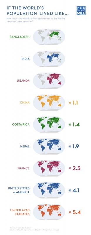
One of our favorites is Per Square Mile's map of "how much space the world's population would take up if everyone lived in one city." It's a fascinating comparison of urban densities. But, as Tim de Chant explains, what's missing from the exercise is how much land it would actually take to support such a city. While such info is hard to come by at the city level, data on resource use is available for countries. So, we'll add a 39th map, developed by de Chant, that compares the ecological footprints of different countries:
FULL STORY: 38 Maps You Never Knew You Needed


Interactive Map Reveals America's “Shade Deserts”
Launched by UCLA and American Forests to combat heat-related deaths, the tool maps the shade infrastructure for over 360 U.S. cities.

Maps: How Much of Your City is Parking?
The percentage of land dedicated to parking in the central districts of major U.S. cities ranges from 4 percent to as much as 42 percent.
Mapping Climate Impact at the Neighborhood Level
A consumption-based analysis illustrates the differences in average household emissions across census tracts.

Maui's Vacation Rental Debate Turns Ugly
Verbal attacks, misinformation campaigns and fistfights plague a high-stakes debate to convert thousands of vacation rentals into long-term housing.

Planetizen Federal Action Tracker
A weekly monitor of how Trump’s orders and actions are impacting planners and planning in America.

In Urban Planning, AI Prompting Could be the New Design Thinking
Creativity has long been key to great urban design. What if we see AI as our new creative partner?

Florida Seniors Face Rising Homelessness Risk
High housing costs are pushing more seniors, many of them on a fixed income, into homelessness.

Massachusetts Budget Helps Close MBTA Budget Gap
The budget signed by Gov. Maura Healey includes $470 million in MBTA funding for the next fiscal year.

Milwaukee Launches Vision Zero Plan
Seven years after the city signed its Complete Streets Policy, the city is doubling down on its efforts to eliminate traffic deaths.
Urban Design for Planners 1: Software Tools
This six-course series explores essential urban design concepts using open source software and equips planners with the tools they need to participate fully in the urban design process.
Planning for Universal Design
Learn the tools for implementing Universal Design in planning regulations.
Gallatin County Department of Planning & Community Development
Heyer Gruel & Associates PA
JM Goldson LLC
City of Camden Redevelopment Agency
City of Astoria
Transportation Research & Education Center (TREC) at Portland State University
Jefferson Parish Government
Camden Redevelopment Agency
City of Claremont