


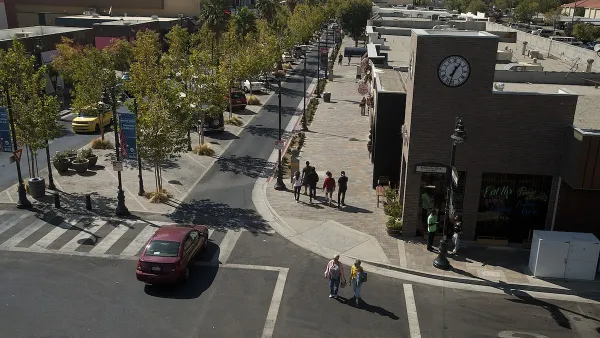
The result of a collaborative effort between five editors and 43 professionals from around the world, a new open-source book documents the essential concepts and strategies for creating great cities at eye level - along the ground floor ("plinths").
Ground floors, or "plinths," are the most crucial parts of buildings for creating great cities. They define the way a city's public and private spaces interact, and are essential to creating commodious pedestrian environments. "The ground floor may be only 10% of a building, [but] it determines 90% of the building’s contribution to the experience of the environment," say editors Hans Karssenberg & Jeroen Laven.
"A great city at eye level requires a strategy based on three domains: software (use, the experience, the functions), hardware (design of plinths, buildings, streetscapes, hybrid zones and principles of sustainability) and orgware (organisation of functions and portfolio maintenance). The 215-‐page book offers ideas, solutions and examples of the best ground floors and ground-‐level planning from cities across the world. The concluding chapter proposes 75 specific lessons for good plinths."
A [PDF] of the book, "The City at Eye Level", is available for free download.
FULL STORY: The City at Eye Level

The Vast Potential of the Right-of-Way
One writer argues that the space between two building faces is the most important element of the built environment.

Opinion: What San Francisco’s Proposed ‘Family Zoning’ Could Really Mean
Mayor Lurie is using ‘family zoning’ to encourage denser development and upzoning — but could the concept actually foster community and more human-scale public spaces?

Car-Centric LA Suburb Looks to a Train-Oriented Future
City leaders in Rancho Cucamonga, the future western terminus of the Brightline West rail line to Las Vegas, want to reimagine the city as a transit-oriented, pedestrian-friendly community.

Maui's Vacation Rental Debate Turns Ugly
Verbal attacks, misinformation campaigns and fistfights plague a high-stakes debate to convert thousands of vacation rentals into long-term housing.

Planetizen Federal Action Tracker
A weekly monitor of how Trump’s orders and actions are impacting planners and planning in America.

In Urban Planning, AI Prompting Could be the New Design Thinking
Creativity has long been key to great urban design. What if we see AI as our new creative partner?

Cal Fire Chatbot Fails to Answer Basic Questions
An AI chatbot designed to provide information about wildfires can’t answer questions about evacuation orders, among other problems.

What Happens if Trump Kills Section 8?
The Trump admin aims to slash federal rental aid by nearly half and shift distribution to states. Experts warn this could spike homelessness and destabilize communities nationwide.

Sean Duffy Targets Rainbow Crosswalks in Road Safety Efforts
Despite evidence that colorful crosswalks actually improve intersection safety — and the lack of almost any crosswalks at all on the nation’s most dangerous arterial roads — U.S. Transportation Secretary Duffy is calling on states to remove them.
Urban Design for Planners 1: Software Tools
This six-course series explores essential urban design concepts using open source software and equips planners with the tools they need to participate fully in the urban design process.
Planning for Universal Design
Learn the tools for implementing Universal Design in planning regulations.
Appalachian Highlands Housing Partners
Gallatin County Department of Planning & Community Development
Heyer Gruel & Associates PA
Mpact (founded as Rail~Volution)
City of Camden Redevelopment Agency
City of Astoria
City of Portland
City of Laramie