


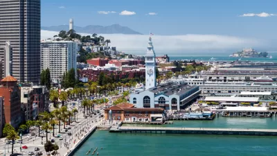
From a giant dam across the Golden Gate to a dozen "ventilated levees," the options proposed for protecting San Francisco Bay from rising seas are neither cheap nor subtle. But with sea level rise "around the corner," hard choices must be made.
The oldest continually operating tidal gauge in the Americas indicates that the waters of San Francisco Bay have risen 8 inches in the past century. That gradual rise is nothing compared to the predicted rise of an additional 1 1/2 feet by 2050 and 6 feet by 2100. Due to such a sea surge, "land equivalent in area to six San Franciscos could regularly flood, inundating vast swaths of the region's airports, high-tech campuses and the homes of more than 100,000 residents, according to the San Francisco Bay Conservation and Development Commission."
"Ultimately," reports James Temple, "there are few good options for confronting this challenge."
"'There are two reactions to dealing with sea level rise; there is fight and there is flight,'" said Will Travis, senior adviser to the Bay Area Joint Policy Committee, which coordinates planning efforts among regional agencies." According to Temple, "planners studying this issue believe that the realities of time, finances, politics and lethargy may force the region to make hard choices about what to protect, what to abandon and what level of risk the region is willing to live with."
Although some believe we don't know enough about the Bay Area's long-term vulnerabilities to seriously consider major protection projects, the reality is that "areas along San Francisco's Embarcadero, Peninsula beaches and, of course, Richardson Bay are already flooding with growing frequency."
"This won't be a problem that starts in 2050;" says Temple, "it's here, and will get worse over time."
FULL STORY: Preparing the bay for rising sea levels

Report: Embarcadero Needs to Rise 7 Feet to Resist Sea-Level Rise
A bombshell report details the adaptation measures that will be necessary to keep San Francisco's Embarcadero high and dry as the climate changes and sea levels rise.

Opinion: High-Rises Won't Sink San Francisco
The weight of large buildings may not be a major threat to coastal cities, despite recent claims.
The Cost of Sea-Level Rise Measured in Tens of Billions in California
A new report summarizes the impact rising sea levels would have on California residents, businesses, and infrastructure. The effects would be catastrophic for the San Francisco Bay Area.

Maui's Vacation Rental Debate Turns Ugly
Verbal attacks, misinformation campaigns and fistfights plague a high-stakes debate to convert thousands of vacation rentals into long-term housing.

Planetizen Federal Action Tracker
A weekly monitor of how Trump’s orders and actions are impacting planners and planning in America.

In Urban Planning, AI Prompting Could be the New Design Thinking
Creativity has long been key to great urban design. What if we see AI as our new creative partner?

King County Supportive Housing Program Offers Hope for Unhoused Residents
The county is taking a ‘Housing First’ approach that prioritizes getting people into housing, then offering wraparound supportive services.

Researchers Use AI to Get Clearer Picture of US Housing
Analysts are using artificial intelligence to supercharge their research by allowing them to comb through data faster. Though these AI tools can be error prone, they save time and housing researchers are optimistic about the future.

Making Shared Micromobility More Inclusive
Cities and shared mobility system operators can do more to include people with disabilities in planning and operations, per a new report.
Urban Design for Planners 1: Software Tools
This six-course series explores essential urban design concepts using open source software and equips planners with the tools they need to participate fully in the urban design process.
Planning for Universal Design
Learn the tools for implementing Universal Design in planning regulations.
planning NEXT
Appalachian Highlands Housing Partners
Gallatin County Department of Planning & Community Development
Mpact (founded as Rail~Volution)
City of Camden Redevelopment Agency
City of Astoria
City of Portland
City of Laramie