


A 22 acre parcel of federal buildings located within spitting distance of the National Mall could transform the heart of the Nation's Capital, as the GSA seeks ideas from developers on how to use its many current and soon-to-be abandoned buildings.
Called Federal Triangle South, the site located only a block from some of D.C.'s premier institutions could accommodate up to 6.1 million square feet of development under current zoning. If planners and city leaders have their way, the site could one day be home to a mix of uses sorely missing from the neighborhood surrounding Washington D.C.'s central attractions.
"The GSA announced at the end of September
that it plans to seek ideas from the private sector for what to do with
the drab cluster of buildings, opening the door to what could be the
largest redevelopment of federal land in downtown Washington since the
Ronald Reagan Building and International Trade Center was built 15 years
ago," reports Jonathan O'Connell. "The stakes for the government and the city are high."
"[The National Capital Planning Commission's Marcel C. Acosta] was one of a number of planning experts who strongly
suggested that the GSA follow recent successes elsewhere in the District
- such as Penn Quarter and Columbia Heights - by incorporating a mix of
uses on the site. And that means housing."
"Condos may never
be added atop the Smithsonian institutions that line the National Mall,
but new high-end housing is creeping closer and closer," says O'Connell.
FULL STORY: Neighborhood living near the National Mall?

An American Lockdown
Words matter. Road safety advocates know that "crashes are not accidents." Similarly, calling coronavirus restrictions "lockdowns," fails to distinguish the severity among public health orders. On January 6, America experienced a true lockdown.
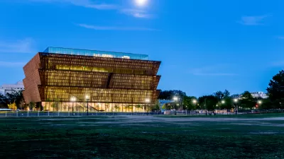
The National Museum of African American History and Culture Takes Its Rightful Place
The reviews are pouring in for the new National Museum of African American History and Culture, set to open on September 24, 2016.
What is the Role of the National Mall?
The cancellation of the Hirshhorn Museum's bubble project has Dan Malouff pondering the role of the National Mall. Should it be an urban room whose buildings define its open space, or the setting for risk-taking architecture?

Maui's Vacation Rental Debate Turns Ugly
Verbal attacks, misinformation campaigns and fistfights plague a high-stakes debate to convert thousands of vacation rentals into long-term housing.

Planetizen Federal Action Tracker
A weekly monitor of how Trump’s orders and actions are impacting planners and planning in America.

In Urban Planning, AI Prompting Could be the New Design Thinking
Creativity has long been key to great urban design. What if we see AI as our new creative partner?

Massachusetts Budget Helps Close MBTA Budget Gap
The budget signed by Gov. Maura Healey includes $470 million in MBTA funding for the next fiscal year.

Milwaukee Launches Vision Zero Plan
Seven years after the city signed its Complete Streets Policy, the city is doubling down on its efforts to eliminate traffic deaths.

Portland Raises Parking Fees to Pay for Street Maintenance
The city is struggling to bridge a massive budget gap at the Bureau of Transportation, which largely depleted its reserves during the Civd-19 pandemic.
Urban Design for Planners 1: Software Tools
This six-course series explores essential urban design concepts using open source software and equips planners with the tools they need to participate fully in the urban design process.
Planning for Universal Design
Learn the tools for implementing Universal Design in planning regulations.
Gallatin County Department of Planning & Community Development
Heyer Gruel & Associates PA
JM Goldson LLC
City of Camden Redevelopment Agency
City of Astoria
Transportation Research & Education Center (TREC) at Portland State University
Jefferson Parish Government
Camden Redevelopment Agency
City of Claremont