


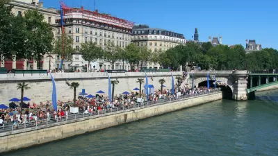
Michael Kimmelman paints an idyllic picture along the Bronx River in New York, where the waterfront along "one of the most blighted, abused waterways in the country" is being transformed park by park.
As old industrial waterfronts throughout the five boroughs undergo a dramatic transformation, Kimmelman spotlights an area of "special priority" to the Bloomberg administration that has flowed beneath the radar.
Here, along the south end of the Bronx River, "a patchwork of green spaces has been taking shape, the
consequence of decades of grinding, grass-roots, community-driven
efforts. For the environmentalists, educators, politicians, architects
and landscape designers involved, the idea has not just been to
revitalize a befouled waterway and create new public spaces. It has been
to invest Bronx residents, for generations alienated from the water, in
the beauty and upkeep of their local river."
For Kimmelman, the jumble of projects, which aim to add up to the long-term recovery of a great waterway and its neighborhoods, "illustrates how government, although it can be obstructionist and
infuriating, is also indispensable to urban improvement."
"What's emerging in the Bronx is past and future. A new, more equitable
vision for the city in the 21st century. And a river returned, at least
partly, to its former glory."
FULL STORY: River of Hope in the Bronx

River Scenes: How Rivers Contribute to More Vibrant Urban Communities
The role of rivers in urban areas shifted in recent years from production to consumption. Now, access to a river's waterfront has become a highly valued amenity within cities.
Are Movie Studios 'Highest and Best Use' During a Housing Affordability Crisis?
Toronto's answer to the question posed in the headline is, "yes." One columnist wonders if the city can do more to balance its priorities.
Opinion: N.Y.C. Neighborhood Rezoning Displaces Vulnerable Residents
Rezoning has resulted in the loss of affordable housing in areas like the South Bronx, and any proposals need to consider the long-term racial equity impacts, according to a recent report by Churches United for Fair Housing.

Planetizen Federal Action Tracker
A weekly monitor of how Trump’s orders and actions are impacting planners and planning in America.

Chicago’s Ghost Rails
Just beneath the surface of the modern city lie the remnants of its expansive early 20th-century streetcar system.

San Antonio and Austin are Fusing Into one Massive Megaregion
The region spanning the two central Texas cities is growing fast, posing challenges for local infrastructure and water supplies.

Since Zion's Shuttles Went Electric “The Smog is Gone”
Visitors to Zion National Park can enjoy the canyon via the nation’s first fully electric park shuttle system.

Trump Distributing DOT Safety Funds at 1/10 Rate of Biden
Funds for Safe Streets and other transportation safety and equity programs are being held up by administrative reviews and conflicts with the Trump administration’s priorities.

German Cities Subsidize Taxis for Women Amid Wave of Violence
Free or low-cost taxi rides can help women navigate cities more safely, but critics say the programs don't address the root causes of violence against women.
Urban Design for Planners 1: Software Tools
This six-course series explores essential urban design concepts using open source software and equips planners with the tools they need to participate fully in the urban design process.
Planning for Universal Design
Learn the tools for implementing Universal Design in planning regulations.
planning NEXT
Appalachian Highlands Housing Partners
Mpact (founded as Rail~Volution)
City of Camden Redevelopment Agency
City of Astoria
City of Portland
City of Laramie