


Last week, landscape architect James Corner presented a transformative vision for remaking Seattle's waterfront after the removal of the Alaskan Way Viaduct. Lynn Thompson describes Corner's plan, and its accompanying funding challenges.
A heated saltwater swimming pool on a barge? A seasonal roller rink on a pier? A mist machine? Sign us up for a visit to Seattle's waterfront of the future, as presented last week in the latest iteration of a plan by James Corner Field Operations, refined after months of public consultation. Other elements of the plan include parks, pathways and public plazas intended to provide increased public access to the waterfront year-round.
Compared favorably to, "two of Seattle's major civic
undertakings - the 1962 World's Fair and the Forward Thrust initiative
in the late 1960s that built the Kingdome, cleaned up Lake Washington
and built dozens of public swimming pools and community centers," Corner's plan is being enthusiastically endorsed by the city's Central Waterfront Committee.
Now about that $420 million price tag, which the Waterfront Committee's finance subcommittee believes, "half of which would come from a local improvement district funded by
downtown property owners, with the rest from city taxpayers and private
donors," writes Thompson.
"Members of the finance committee said their funding plan is both realistic and achievable."
"We went into this worrying about the scale," said Gerry Johnson, a
Seattle attorney and co-chairman. "We've emerged being very confident
that this is something we can accomplish."
FULL STORY: After the Alaskan Way Viaduct, city sees 'a waterfront for all'

Checking in on Seattle's Ambitious Waterfront Park Plans
A recent article by Bill Lucia explains the reasons to be cautiously optimistic about a proposed park that will replace a demolished Alaskan Viaduct on Seattle’s waterfront.
A New Waterfront in the Works for Seattle
Seattle is panning to tear down an aging viaduct that runs along its waterfront and replace it with a tunnel beneath downtown. When the viaduct falls, the city is looking to increase public space on a new waterfront.
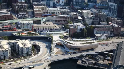
Seattle’s New Overlook Walk Offers Ample Park Space Near Pike Place Market
The elevated park and event space replaces part of the demolished Alaskan Way Viaduct, connecting the city’s famous Pike Place Market to the waterfront.

Planetizen Federal Action Tracker
A weekly monitor of how Trump’s orders and actions are impacting planners and planning in America.

Chicago’s Ghost Rails
Just beneath the surface of the modern city lie the remnants of its expansive early 20th-century streetcar system.

San Antonio and Austin are Fusing Into one Massive Megaregion
The region spanning the two central Texas cities is growing fast, posing challenges for local infrastructure and water supplies.

Since Zion's Shuttles Went Electric “The Smog is Gone”
Visitors to Zion National Park can enjoy the canyon via the nation’s first fully electric park shuttle system.

Trump Distributing DOT Safety Funds at 1/10 Rate of Biden
Funds for Safe Streets and other transportation safety and equity programs are being held up by administrative reviews and conflicts with the Trump administration’s priorities.

German Cities Subsidize Taxis for Women Amid Wave of Violence
Free or low-cost taxi rides can help women navigate cities more safely, but critics say the programs don't address the root causes of violence against women.
Urban Design for Planners 1: Software Tools
This six-course series explores essential urban design concepts using open source software and equips planners with the tools they need to participate fully in the urban design process.
Planning for Universal Design
Learn the tools for implementing Universal Design in planning regulations.
planning NEXT
Appalachian Highlands Housing Partners
Mpact (founded as Rail~Volution)
City of Camden Redevelopment Agency
City of Astoria
City of Portland
City of Laramie