


John King considers a new report released by the Census Bureau on Monday, which finds that of the ten most densely populated urbanized areas in the United States, nine are in the West.
As King comments, the Census Report "reaffirmed a counterintuitive truth: The cities of the West, barely considered cities at all by many East Coast pundits, often are more densely populated than such skyscraping metropolises as New York and Chicago."
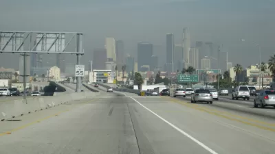
The four most densely urbanized areas were all in California, with Los Angeles-Long Beach-Anaheim (nearly 7,000 people/sq mi), San Francisco-Oakland (6,266 people/sq mi), and San Jose (5,820 people/sq mi) topping the list. Of course, the New York-Newark area continues to be the most populous area, with 18,351,295 residents.
According to King, the density numbers, which are shaped by commute patterns and geographic features, rather than municipal boundaries, reflect the unique historic growth patterns of the West where there are "much more rigid lines of separation" between urban, rural, and wilderness land.
"It's a legacy of how in our minds' eye we have always separated California into 'urban' land and 'productive' land and then wilderness, the cathedrals of nature," said Jon Christensen, executive director of the Bill Lane Center for the American West at Stanford University.
Also of note in the Census Bureau's findings is that the nation's urban population as a whole "increased by 12.1 percent from 2000 to 2010, outpacing the nation's overall growth rate of 9.7 percent for the same period." In addition, "Among urbanized areas with populations of 1 million or more, the Charlotte, N.C.-S.C., area grew at the fastest rate, increasing by 64.6 percent."
For King however, "The most intriguing nugget found in the density measurements might be the hints that the American norm of growth - ever outward, with densities in a constant decline - might be coming to a halt in certain desirable locales."
FULL STORY: California cities most densely populated in U.S.

California Redefines Density
Census data reveals that California is the most urbanized state, with the most dense urban areas. But in California, sprawl, density, crowding, and urbanism are not always what they seem. Fortunately, a new law may help planners make sense of it all.
California Has 8 of the 10 Most Polluted Cities in the U.S.
Despite ever-stricter air-quality regulations and dropping emissions, the American Lung Association once again finds the state to have some of the worst air in the nation.

Unhoused People in San Jose Could Face Arrest if They Refuse Shelter
A policy proposed by the city’s mayor would give law enforcement the option to arrest homeless residents if they refuse three offers of housing.

Planetizen Federal Action Tracker
A weekly monitor of how Trump’s orders and actions are impacting planners and planning in America.

Maui's Vacation Rental Debate Turns Ugly
Verbal attacks, misinformation campaigns and fistfights plague a high-stakes debate to convert thousands of vacation rentals into long-term housing.

San Francisco Suspends Traffic Calming Amidst Record Deaths
Citing “a challenging fiscal landscape,” the city will cease the program on the heels of 42 traffic deaths, including 24 pedestrians.

Defunct Pittsburgh Power Plant to Become Residential Tower
A decommissioned steam heat plant will be redeveloped into almost 100 affordable housing units.

Trump Prompts Restructuring of Transportation Research Board in “Unprecedented Overreach”
The TRB has eliminated more than half of its committees including those focused on climate, equity, and cities.

Amtrak Rolls Out New Orleans to Alabama “Mardi Gras” Train
The new service will operate morning and evening departures between Mobile and New Orleans.
Urban Design for Planners 1: Software Tools
This six-course series explores essential urban design concepts using open source software and equips planners with the tools they need to participate fully in the urban design process.
Planning for Universal Design
Learn the tools for implementing Universal Design in planning regulations.
Heyer Gruel & Associates PA
JM Goldson LLC
Custer County Colorado
City of Camden Redevelopment Agency
City of Astoria
Transportation Research & Education Center (TREC) at Portland State University
Jefferson Parish Government
Camden Redevelopment Agency
City of Claremont