


A lecture series explores the relation between city planning and urban violence. And who is to blame? The architect.
Although first published on YouTube in April, 2011, this video is making the rounds among planners on the Internet.
Blame the Architect is a lecture series by professor Wouter Vanstiphout on the relation between city planning and urban violence, organized by the chair of Design as Politics at the Delft University of Technology.
In this first lecture, the general theme of the series is introduced. The interesting section begins at 10:05 in the video.
From Professor Vanstiphout's lecutre: "Let us examine the riots in the French cities [Les émeutes des banlieues de 2005] in the Autumn 2005. In the outskirts of Paris, riots started that spread... to the outskirts of nearly all French cities. It was a completely new thing. There was a kind of weird discovery that triggered an enormous... preconception... [about] the relationship among planning, crime, poverty, alienation. It turned out that without exception, all these riots happened in post-war modernest, high-rise, public housing complexes. You can image who got the blame... The architect."
Thanks to John Massengale
FULL STORY: Blame the Architect: Lecture 1 part 1/7

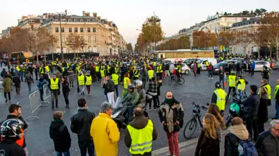
Fuel Tax Hike Revolt Threatens French President Macron's Leadership
Anger at fuel tax increases planned for January, part of a pro-Green agenda espoused by President Emmanuel Macron, has sparked a populous movement involving hundreds of thousands of protestors that have taken to the streets, erupting into violence.
French Utopia Devolves
Born from the 1968 riots, a carefully planned community in France has been steadily taken over by crime and unrest, prompting some to question whether its utopian ideals actually work.

France Tightens Restrictions on Short-Term Rentals
The vacation rental market is shouldering part of the blame for rising housing costs, particularly in popular tourist destinations.

Maui's Vacation Rental Debate Turns Ugly
Verbal attacks, misinformation campaigns and fistfights plague a high-stakes debate to convert thousands of vacation rentals into long-term housing.

Planetizen Federal Action Tracker
A weekly monitor of how Trump’s orders and actions are impacting planners and planning in America.

Chicago’s Ghost Rails
Just beneath the surface of the modern city lie the remnants of its expansive early 20th-century streetcar system.

Bend, Oregon Zoning Reforms Prioritize Small-Scale Housing
The city altered its zoning code to allow multi-family housing and eliminated parking mandates citywide.

Amtrak Cutting Jobs, Funding to High-Speed Rail
The agency plans to cut 10 percent of its workforce and has confirmed it will not fund new high-speed rail projects.

LA Denies Basic Services to Unhoused Residents
The city has repeatedly failed to respond to requests for trash pickup at encampment sites, and eliminated a program that provided mobile showers and toilets.
Urban Design for Planners 1: Software Tools
This six-course series explores essential urban design concepts using open source software and equips planners with the tools they need to participate fully in the urban design process.
Planning for Universal Design
Learn the tools for implementing Universal Design in planning regulations.
planning NEXT
Appalachian Highlands Housing Partners
Mpact (founded as Rail~Volution)
City of Camden Redevelopment Agency
City of Astoria
City of Portland
City of Laramie