


Ryan Donahue of the Trust for Public Land says that it depends on age, health, time availability, quality of surroundings, safety, climate, and many other factors.
One problem with assessing how far people will walk to use a park is that most walkability studies are focused on commuters rather than park users who have a mix of motivations. However, it does seem that the quarter-mile standard used to assess the walkability of transit stations is mostly applicable to parks as well:
"...research supports the validity of both quarter-mile and half-mile distance goals, depending on perceptions of the built environment, safety, and time constraints. Of course, people's preferences and habits are only part of the equation for planners, who must also take into account the cost effectiveness of expanding the park system versus improving current parks or focusing on connectivity."
FULL STORY: Pedestrians and Park Planning: How Far Will People Walk?


Car-Centric LA Suburb Looks to a Train-Oriented Future
City leaders in Rancho Cucamonga, the future western terminus of the Brightline West rail line to Las Vegas, want to reimagine the city as a transit-oriented, pedestrian-friendly community.
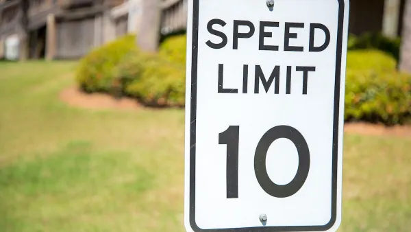
Washington Passes First US ‘Shared Streets’ Law
Cities will be allowed to lower speed limits to 10 miles per hour and prioritize pedestrians on certain streets.

What the ‘Walk Score’ Misses
A popular walkability assessment omits key factors that impact different demographics and can direct development resources to already wealthy neighborhoods.

Planetizen Federal Action Tracker
A weekly monitor of how Trump’s orders and actions are impacting planners and planning in America.

Maui's Vacation Rental Debate Turns Ugly
Verbal attacks, misinformation campaigns and fistfights plague a high-stakes debate to convert thousands of vacation rentals into long-term housing.

San Francisco Suspends Traffic Calming Amidst Record Deaths
Citing “a challenging fiscal landscape,” the city will cease the program on the heels of 42 traffic deaths, including 24 pedestrians.

Amtrak Rolls Out New Orleans to Alabama “Mardi Gras” Train
The new service will operate morning and evening departures between Mobile and New Orleans.

The Subversive Car-Free Guide to Trump's Great American Road Trip
Car-free ways to access Chicagoland’s best tourist attractions.

San Antonio and Austin are Fusing Into one Massive Megaregion
The region spanning the two central Texas cities is growing fast, posing challenges for local infrastructure and water supplies.
Urban Design for Planners 1: Software Tools
This six-course series explores essential urban design concepts using open source software and equips planners with the tools they need to participate fully in the urban design process.
Planning for Universal Design
Learn the tools for implementing Universal Design in planning regulations.
Heyer Gruel & Associates PA
JM Goldson LLC
Custer County Colorado
City of Camden Redevelopment Agency
City of Astoria
Transportation Research & Education Center (TREC) at Portland State University
Jefferson Parish Government
Camden Redevelopment Agency
City of Claremont