


In a recent blog post,(1) highway expert Alan Pisarski suggests that highway-oriented sprawl development is somehow necessary for the development of modern labor markets.(2) Pisarski writes that regional job markets are jobs are more specialized today than they were in his youth, and labor markets are thus "of immense size because many [highly specialized] employers need a market of hundreds of thousands of potential workers to reach the ones they need. The Atlanta region of 26 counties is not a great economic engine because it is 26 charming adjacent hamlets, but rather because the market reach of employers, suppliers, customers and job seekers spreads over several million residents."

In a recent blog post,(1) highway expert Alan Pisarski suggests that highway-oriented sprawl development is somehow necessary for the development of modern labor markets.(2) Pisarski writes that regional job markets are jobs are more specialized today than they were in his youth, and labor markets are thus "of immense size because many [highly specialized] employers need a market of hundreds of thousands of potential workers to reach the ones they need. The Atlanta region of 26 counties is not a great economic engine because it is 26 charming adjacent hamlets, but rather because the market reach of employers, suppliers, customers and job seekers spreads over several million residents."
In other words, for a labor market to function at peak efficiency, (a) employers and employees must be able to draw on the entire region for jobs, and (b) highway-driven, Atlanta-like sprawl(3) facilitates this match in a way that walkable communities don't. Assumption (a) makes sense to me; Assumption (b) does not.
Instead, it seems to me that employers and employees can reach each other more easily in a less sprawling, car-oriented region. Why? Because they can travel shorter distances to do so, and can do so in a broader variety of ways.
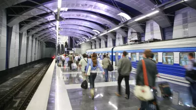
In both Atlanta and in less car-dominated regions, most people have jobs outside their own neighborhoods. But in Atlanta, many of those people will have to drive 10 or 20 (or even more) miles to reach those jobs. In New York or Tokyo, many (admittedly not all) of those people will be able to reach those jobs via walking or public transit, and because these regions are more compact than Atlanta, more people will be able to commute fewer miles to reach those jobs, regardless of their modes of transportation.
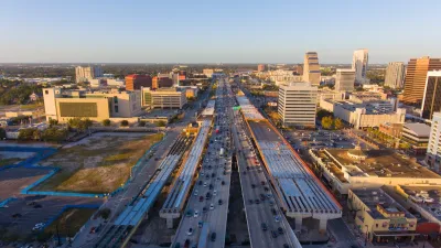
To illustrate the point more precisely, imagine two regions, Atlanta and Compactville. Atlanta's urbanized area has 4.4 million people spread out over about 3000 square miles. (4) Compactville has a New York City-like density of around 20,000 people per square mile, which means its 4.4 million people occupy about 220 square miles. Compactville's residents, like Atlanta's, don't all work downtown or near their homes. Many of them commute from one end of Compactville to another. But in a 220-square-mile region, most residents of the north end of Compactville will be a closer to the south end (and to public transit that can take them to the south end) than in Atlanta, which, bus and train speeds being equal, means that more of them will be able to use public transit than in Atlanta, which in turn means that nondrivers are not shut out of the labor market to the same extent as in Atlanta. Thus, Compactville's lack of sprawl actually expands the local labor market.
Similarly, Compactville's lack of sprawl expands the retail market as well. Pisarski suggests otherwise, writing "If you want a loaf of Wonder Bread, there's a 7-11 down the street; if its ciabatta with sun-dried tomatoes there's this really great place I know a few miles off of exit 29." But in a more compact metropolis, more people will be within walking distance of that ciabatta - and the people that aren't will be within transit-riding distance. By contrast, in sprawling cities, the only way for most people to reach that ciabatta is to take the freeway, because low densities and pedestrian-hostile environments mean that very few people will be within walking distance of that ciabatta.
(1) http://www.newgeography.com/content/001865-livability-and-all-that
(2) This is not Pisarski's only argument; however, many of his other assertions have been criticized elsewhere. See http://newurbannetwork.com/news-opinion/blogs/robert-steuteville/13540/livability-means-being-poor-and-eating-only-one-kind-let
(3) I note in passing that Pisarski's description of Atlanta as a "great economic engine" is a bit out of date. Metro Atlanta's unemployment rate is 10 percent- higher than that of the nation as a whole, and higher than that of numerous less-sprawling places. See http://www.bls.gov/web/metro/laummtrk.htm ; see also Nelson D. Schwartz, Modernizing as a road towards recovery, International Herald Tribune, Feb. 5, 2010 (unemployment rate is 4 percent in Netherlands, 5.4 percent in Austria).
(4) http://mobility.tamu.edu/ums/congestion_data/tables/atlanta.pdf

Disconnecting Communities: Measuring the Social Impacts of Freeways
Research from 50 major U.S. cities shows social connections are weakest in neighborhoods where highways are present.

Highway Removal Slowed by Outdated Policy, Lack of Committed Funding
Resistance from state transportation departments and precarious funding sources mean highway removal projects are few and far between, despite their benefits.
Freedom to Move: Investing in Transportation Choices for a Clean, Prosperous, and Just Future
This Union of Concerned Scientists study examines why and how to improve resource-efficient travel options to achieve diverse goals. It estimates that more efficient transport could save up to $201 billion in energy and $128 billion in health costs.

Maui's Vacation Rental Debate Turns Ugly
Verbal attacks, misinformation campaigns and fistfights plague a high-stakes debate to convert thousands of vacation rentals into long-term housing.

Planetizen Federal Action Tracker
A weekly monitor of how Trump’s orders and actions are impacting planners and planning in America.

San Francisco Suspends Traffic Calming Amidst Record Deaths
Citing “a challenging fiscal landscape,” the city will cease the program on the heels of 42 traffic deaths, including 24 pedestrians.

Defunct Pittsburgh Power Plant to Become Residential Tower
A decommissioned steam heat plant will be redeveloped into almost 100 affordable housing units.

Trump Prompts Restructuring of Transportation Research Board in “Unprecedented Overreach”
The TRB has eliminated more than half of its committees including those focused on climate, equity, and cities.

Amtrak Rolls Out New Orleans to Alabama “Mardi Gras” Train
The new service will operate morning and evening departures between Mobile and New Orleans.
Urban Design for Planners 1: Software Tools
This six-course series explores essential urban design concepts using open source software and equips planners with the tools they need to participate fully in the urban design process.
Planning for Universal Design
Learn the tools for implementing Universal Design in planning regulations.
Heyer Gruel & Associates PA
JM Goldson LLC
Custer County Colorado
City of Camden Redevelopment Agency
City of Astoria
Transportation Research & Education Center (TREC) at Portland State University
Jefferson Parish Government
Camden Redevelopment Agency
City of Claremont