


Wendell Cox questions the economic impact of the city's much-celebrated land use and transportation policies, which are intended to strengthen the urban core and discourage sprawl.
Cox suggests that stringent growth regulations by Portland Metro, the three county planning body, cause the region to lose jobs and residents to its neighbors. While Multnomah County, the core of the Portland metro region, lost 20,000 jobs between 2001 and 2009, nearby Clark County, which has less stringent land use regulations and lower housing prices, added 13,000.
Cox also argues that the city is over-investing in transit at the expense of roadways, spending $5 billion on new light rail and bus systems over the past 25 years even as telecommuting is on the rise. In 2009, nearly as many residents worked from home as commuted on public transit.
'A higher cost of living driven by policies that have kept prices 40% higher than before the housing bubble (adjusted for household incomes), and increasing traffic congestion make Portland's three county area less competitive and nearby alternatives more attractive,' writes Cox.
FULL STORY: Portland Metro's Competitiveness Problem


USDOT Releases Climate Strategies Playbook
The USDOT's new Climate Strategies that Work Playbook provides detailed information concerning benefits and implementation requirements for 27 transportation-related emission reduction strategies.

Calculating Vehicle Travel Reduction Benefits
The Rocky Mountain Institute's new Smarter MODES Calculator quantifies economic, social and environmental benefits provided by shifts from automobile travel to more resource-efficient modes. This includes benefits that are often overlooked or undervalued in conventional planning.
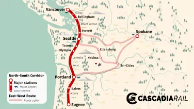
Cascadia High-Speed Rail Corridor Seeking Federal Funding
The state of Washington is hoping federal infrastructure funding can pay for $198 million of the $348 million necessary to plan the Cascadia High-Speed Rail project.

Montreal Mall to Become 6,000 Housing Units
Place Versailles will be transformed into a mixed-use complex over the next 25 years.

Planetizen Federal Action Tracker
A weekly monitor of how Trump’s orders and actions are impacting planners and planning in America.

DARTSpace Platform Streamlines Dallas TOD Application Process
The Dallas transit agency hopes a shorter permitting timeline will boost transit-oriented development around rail stations.

Without International Immigrants, the Rural US Population Would Be Falling 58%
Census data shows that population growth in rural areas is due in large part to international migrants.

Dead End: Nine Highways Ready for Retirement
The Freeways Without Futures report describes the nation’s most promising highway removal proposals.

Congressman Proposes Bill to Rename DC Metro “Trump Train”
The Make Autorail Great Again Act would withhold federal funding to the system until the Washington Metropolitan Area Transit Authority (WMATA), rebrands as the Washington Metropolitan Authority for Greater Access (WMAGA).
Urban Design for Planners 1: Software Tools
This six-course series explores essential urban design concepts using open source software and equips planners with the tools they need to participate fully in the urban design process.
Planning for Universal Design
Learn the tools for implementing Universal Design in planning regulations.
City of Mt Shasta
City of Camden Redevelopment Agency
City of Astoria
Transportation Research & Education Center (TREC) at Portland State University
City of Camden Redevelopment Agency
Municipality of Princeton (NJ)
Regional Transportation Commission of Southern Nevada