


While Madrid's urban core is highly dense, the city has sprawled out over the last two decades much further than its growing population requires, says Madrid resident and planning consultant Marco Adelfio.
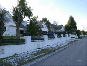
 From the nineteen-eighties until today, the expansion of Madrid has been characterized by disproportionate land consumption in comparison with the actual population growth. Between 1980 and 1999, the amount of urbanized land increased by nine times the growth of the population of the metropolitan area. Given this context, it is possible to observe a change in the characteristics of the living space. One of the most significant aspects of change was an increase of the number of detached houses in the metropolitan area, creating a type of suburban landscape based on low density.
The neoliberal ideology, which had its beginnings in the American policies of the Eighties, has characterized the last thirty years of world history, fostering a new kind of development based on decentralization, deregulation and liberalization of markets. The impact that this ideology has had on the territory is extremely significant as it has modified the ways of structuring space and the built environment, changing the idea of urban landscape.
This kind of ideology expressed its influence on the Spanish economy in three ways:
- Irrational exuberance, which led to the development of the speculative bubble.
- Preponderance of ownership over renting, fostered at the same time by the financial institutions and the government, through fiscal benefits.
- Urban planning in the service of the economy, which facilitated a sort of liberalization of the land.
The results that could be observed in Spain were an overproduction of buildings that augmented the effects of the current economic crisis and, at the same time, the promotion of a development based on dispersion, in which the waste of land was greater than the real increase of population.
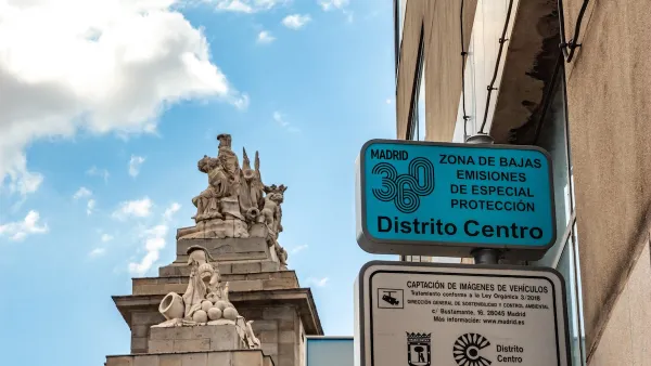
In Spain, this kind of attitude was also displayed by the government, the most evident effect being the National Law of 1998, which declared that all the land not being protected was potentially urbanizable. This implies a liberalization of the land. This principle is in contrast with the traditional European concept of Planning, which designates the urbanizable land according to the real needs of a city.
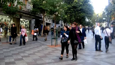
The European Mediterranean city should not be idealized and while you can easily identify a central core of a European metropolis, it is not so easy to distinguish between the periphery of a city like Madrid and the outskirts of an American metropolis.
This does not mean that everything was made using a low density model - you can obviously find a dense urbanity especially in the suburban areas nearest to the core - but the detached house has become the preferred model for the upper classes.
The most important factors that contributed to the establishment of this particular way of living in Madrid are the following:
- A detached house is considered a demonstration of acquisitive power.
- A detached house is the preferred choice for those who decide to live far from the chaotic centre of the city.
- The high prices of land in the urban core make it possible to buy a larger house in the suburbs at a lower price.
- The creation of new centralities, business and commercial areas in the outskirts of the city created new jobs and elements of attraction for the population.
- The automobile is certainly the most commonly used form of transport in such dispersed areas, despite the notable extension of the subway in recent years.
- The possibility of obtaining from banks, during the last decade, a significant amount of money for a mortgage, with a long duration (40-50 years) financing 100% of the value of the house.
The suburban explosion, as the American experience shows, is strictly linked to the development of motorways and infrastructures, both of which have an important role in fostering this kind of model. The dispersed neighborhoods in Madrid were built along the most important motorways, such as the A-1 which connects Madrid to Burgos, direction North, and the A-6, which connects Madrid to La Coruña, Galicia.
Some of those neighbourhoods were originally created by Levitt-Bosch Aymerich who broke into the Spanish housing market in 1973 with the opening of its first community, Monteclaro, though until the Eighties the detached house was essentially a second home.
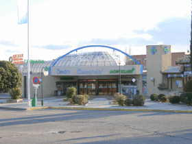
Learning the lesson from the American suburbs, the mall becomes a perfect neighbor for this kind of settlement.
This residential pattern is just one of the elements of the Madrid sprawl. The remaining two are, of course, big box retail and the corporate or office park. These three elements display many characteristics of the U.S. suburbs.
Beginning in the Eighties the population has started to move to the outskirts of Madrid and consequently there has been a gradual replacement of the traditional shop in favour of the big mall situated along the highways and motorways.
The Americanization of shopping was also facilitated by the end of the dictatorship which marked Spain until the second half of the Seventies.
Some of these buildings are constructed in a real American style, with a big box shopping center surrounded by underused parking lots, wasting a huge amount of land. A clear example of an American style mall is the Xanadú Commercial Centre in Móstoles, a town in the South of the Madrid metropolitan area, near the A-5, the motorway that connects Madrid to Lisboa and Southern Portugal. The extravagant project includes also an artificial ski slope, which is viewed as a novelty in Madrid.
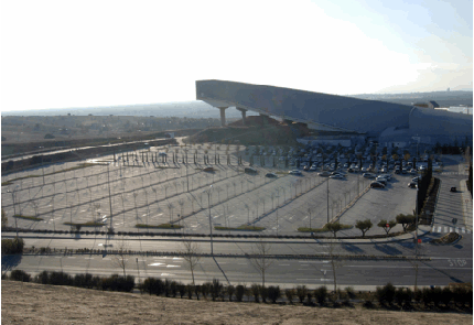
In relation to the corporate parks, the clearest example of American style inspired constructions in Madrid is the Financial City of Santander Bank, the biggest bank in Spain, created in 2004 in Boadilla del Monte, a small town in the western part of the Madrid metropolitan area.
The purpose of this project was to create an integrated peripheral financial district and increase the effectiveness of the employees in a pleasant work environment, bringing together concentration with productivity.
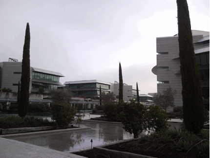
The complex was conceived as a business campus, providing amenities and services for the employees such as restaurants, supermarkets, and a large golf course. This business campus is an enclave development, being access controlled with entry permitted only to the employees.
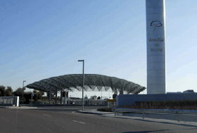
Santander Financial City is a dispersed business area, the building coverage being less than 25% over a 160 hectare surface.
These examples are not intended to demonstrate that Madrid has adopted sprawling development as a unique model, though it is interesting to notice that some parts of the city have commonalities with places situated relatively far from Spain.
I would like to finish the article with a question: Is this the victory of the global or the defeat of the local?
Marco Adelfio is an Urban Planning consultant with a strong interest in Urban Geography. Marco received a M.Sc. in Territorial and Environmental Planning from the University of Rome, Italy, and is now a Ph.D. candidate in Geography at the Autonomous University of Madrid. He holds a B.S. degree in Urban, Territorial and Environmental Planning from the University of Palermo, and has worked in Madrid as a consultant, dealing with large clients such as the Bank of Bilbao (BBVA), the National Agency of Spain for Land Development and Endesa - a leading electricity company in Spain and Latin America.
All photos by the author.

Madrid Uses Transit System for Parcel Delivery to Cut Emissions
A new pilot program uses trains to deliver packages at off-peak hours, lowering emissions from trucks.

Madrid Has the Bike Infrastructure Model the U.S. Needs
A happy accident, Madrid may have stumbled onto a bike infrastructure program with great results. Only time will tell if "slow" lanes yield long-term positive results.
Driving Ban in Madrid Central Survives Despite Change of Leadership
In sharp contrast to France's yellow vest demonstrations against fuel tax hikes, Madrid residents took to the streets to keep them free of motor vehicles after new leaders were elected who vowed to rescind the driving ban enacted last November.

Maui's Vacation Rental Debate Turns Ugly
Verbal attacks, misinformation campaigns and fistfights plague a high-stakes debate to convert thousands of vacation rentals into long-term housing.

Planetizen Federal Action Tracker
A weekly monitor of how Trump’s orders and actions are impacting planners and planning in America.

In Urban Planning, AI Prompting Could be the New Design Thinking
Creativity has long been key to great urban design. What if we see AI as our new creative partner?

King County Supportive Housing Program Offers Hope for Unhoused Residents
The county is taking a ‘Housing First’ approach that prioritizes getting people into housing, then offering wraparound supportive services.

Researchers Use AI to Get Clearer Picture of US Housing
Analysts are using artificial intelligence to supercharge their research by allowing them to comb through data faster. Though these AI tools can be error prone, they save time and housing researchers are optimistic about the future.

Making Shared Micromobility More Inclusive
Cities and shared mobility system operators can do more to include people with disabilities in planning and operations, per a new report.
Urban Design for Planners 1: Software Tools
This six-course series explores essential urban design concepts using open source software and equips planners with the tools they need to participate fully in the urban design process.
Planning for Universal Design
Learn the tools for implementing Universal Design in planning regulations.
planning NEXT
Appalachian Highlands Housing Partners
Mpact (founded as Rail~Volution)
City of Camden Redevelopment Agency
City of Astoria
City of Portland
City of Laramie