


Let me wade into an ongoing debate among fellow Planetizen bloggers Samuel Staley and Michael Lewyn concerning the meanings of accessibility and mobility, and their implications for transportation and land use policy.

Let me wade into an ongoing debate among fellow Planetizen bloggers Samuel Staley and Michael Lewyn concerning the meanings of accessibility and mobility, and their implications for transportation and land use policy.
Accessibility is a general term referring to the ease of obtaining desired goods, services and activities. A number of factors affect accessibility including mobility (physical travel), land use patterns (the geographic distribution of services and activities), and mobility substitutes such as telecommunications and delivery services.
Transportation and land use planning decisions often involve tradeoffs between different forms of accessibility. For example, expanding roadways and parking facilities improves automobile access but tends to reduce pedestrian access, and therefore public transit access since most transit trips include walking links. A location convenient for automobile access, because it is located near a major highway intersection and has generous parking supply, is generally difficult to access without a car. Conversely, improving walking, cycling and public transit access often involves narrowing streets, reducing traffic volumes and reducing the supply of free parking, which reduces automobile access.
During the last century, faster and cheaper automobile transport significantly increased accessibility, but according to my recent analysis (see the section, "Automobile Transportation Productivity, pp. 32-34) those improvements essentially peaked about 1980. Growing traffic congestion and rising fuel prices are reducing automobile transport efficiency. Fortunately, this is being offset by improvements to other forms of accessibility, including mobility substitutes (just a few years ago, obtaining information generally required physical travel to a library, now far more information than any single library contained is accessible almost anywhere through the Internet), and by reurbanization. These accessibility improvements tend to be more cost effective and beneficial overall than accommodating additional automobile travel.
Just as automobiles are machines that provide mobility, urban environments - villages, towns and cities - can be thought of as machines that provide accessibility by minimizing the distance among people and their desired goods, service and activities (shops, schools, jobs, neighbors, etc.). People who live or work in accessible, multi-modal communities, with a suitable mixture of public services within convenient walking distance tend to drive 20-40% less, and use alternative modes much more, than residents of conventional, automobile-oriented communities.
This is good news because automobile transportation is costly. Owning and operating an automobile typically costs about $5,000 annually, plus about $3,000 in higher taxes, rents and retail prices to pay for roads and parking facilities. In addition, high levels of per capita automobile travel increase per capita congestion delays, traffic accidents, land use consumption, energy consumption, pollution emissions, and health problems resulting from sedentary living. It also tends to be inequitable, since non-drivers have less accessibility. Described differently, creating more accessible, smart-growth communities provides various economic, social and environmental benefits, and so represents true sustainability.
Automobile Dependency typically doubles automobile ownership and use, and associated costs, including vehicle ownership and operating costs (and therefore the portion of household budgets devoted to transportation), road and parking infrastructure costs, per capita traffic fatality, energy consumption, pollution emissions and land use consumption. These impacts can be perceived by comparing travel patterns between transit-oriented and sprawled neighborhoods in U.S. cities (see the figure below); by comparing differences in travel patterns between multi-modal and more sprawled U.S. cities (such as between Davis, California where residents average 13.9 daily vehicle-miles and Houston, Texas where residents average 34.0 daily vehicle-miles); and by comparing U.S. travel patterns with those of other wealthy countries, such as Norway and Switzerland. For example, U.S. residents devote approximately 20% of household incomes to transportation (motor vehicles, public transit and residential parking), which is about twice the amount spent on average by Swiss residents. Interestingly, there are no measurable differences in the amount of time people spend on travel between multi-modal and automobile dependent locations; residents of more automobile-oriented communities are able to travel somewhat faster, but their destinations are more dispersed so they save no time overall.
TOD Impacts On Transport Activity in Portland, Oregon (Ohland and Poticha 2006)
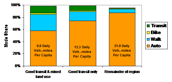
Residents of neighborhoods with good transit service and land use mix drive about half as much, and walk, bike and use public about four times as much, as residents of conventional, automobile-dependent suburban communities.
In a recent blog, Samuel Staley argues that, with just a few exceptions such as Manhattan, NY, most North American communities lack the density required for multi-modal accessibility. According to his analysis the majority of North American communities are automobile-dependent - so "transportation" means automobile travel and "transportation improvement" means expanding roads and parking facilities, and maintaining low fuel and parking prices. I think his analysis overlooks some critical issues.
First, regional-scale density analysis fails to account for many factors that affect accessibility. For example, according to census data, Los Angeles is the densest urban area in the U.S., but many other communities are more multi-modal because of other attributes such as having good land use mix, concentrated commercial centers, connectivity, good walkability, pedestrian-oriented buildings, less parking supply and more parking pricing. Focusing on density confuses the issue by implying that multi-modal accessibility requires Manhattan-style land use patterns. On the contrary, many rural villages and small towns are relatively multi-modal because they have sidewalks on all streets, a nice downtown with a suitable mix of shops and public services, neighborhood parks, and regular bus service to nearby centers.
Second, conventional travel surveys tend to undercount and therefore undervalue walking and cycling because they often overlook short trips, non-work travel, off-peak travel, travel by children, recreational travel and the walking links of trips that involve motorized modes. For example, a bike-bus-walk trip is generally coded simply as a transit trip, and a trip that involves ten minutes of driving to downtown and twenty minutes of walking around downtown is generally coded as an automobile trip – the walking and biking links are invisible even if they use public facilities such as sidewalks, paths and roads. Although conventional travel data typically indicates that only 3-5% of travel is by non-motorized modes, more comprehensive surveys indicate that the actual numbers are two to six times higher. This suggests that walking and cycling are more important than generally recognized, and which increases the justification for walking and cycling improvements.
Third, the high degree of automobile-dependency experienced in most North American communities is not a benign outcome of neutral planning that responded to consumer preferences; it is the costly result of market distortions that favor mobility over accessibility and automobile transport over alternative modes, such as generous minimum parking requirements, limits on development density and mix, underpricing of roads and vehicle fuel, dedicated roadway funding that could not be used for alternative modes or mobility management programs even if they are more cost effective overall, and planning practices that create a hostile environment to walking. These policy distortions encouraged public officials to define transportation problems as simply inadequate roadway capacity, since highway expansion was funded with generous matching grants, while negative impacts (such as the way that increased vehicle traffic and sprawl reduces other types of accessibility) were ignored. For a fascinating discussion of this history see Brown, Morris and Taylor's recent article, "Paved With Good Intentions: Fiscal Politics, Freeways, and the 20th Century American City."
Fourth, there is growing demand for alternative modes and more accessible, multi-modal communities, due to current demographic and economic trends including aging population, rising future fuel prices, increasing traffic congestion, and increasing consumer preferences for urban living. According to market research, twenty years ago about two-thirds of households preferred large-lot, automobile-dependent sprawl housing locations, but this portion has declined to about half and is projected to decline to about one-third of total households due to demographic and economic trends. As a result, the policy reforms needed to create more accessible, multi-modal communities are not a government imposition on consumers, they are actually responding to consumer demands. Of course, there is still plenty of potential for conflict - existing community residents tend to resist change, such as infill, multi-modal housing and new parking restrictions or pricing - but increased urbanization provides overall benefits to most individuals and society.
Unfortunately, most transport system performance indicators (such as roadway level-of-service, average traffic speeds and per-mile crash rates) are based on mobility and ignore other forms of accessibility. As Lewyn recently pointed out, this type of analysis favors transportation improvements that increase vehicle mileage over those that reduce the need for travel. For example, when traffic congestion is measured by roadway level-of-service, higher density areas look worse, although high density cities actually experience less annual congestion delay per capita compared with more automobile-dependent sprawled areas, because residents of dense cities have shorter travel distances and better transport alternatives, and so spend less time driving during peak periods.
Similarly, when measured per 100 million vehicle-miles, U.S. traffic fatality rates declined significantly during the last half-century, implying that existing safety programs are effective, but when measured annual per capita, as with other health risks, traffic fatality rates hardly declined between 1960 and 2005, despite increases seat belt use, reduced drunk driving, safer road and vehicle design, and improved medical care, all of which should have increased safety. This occurred because reduced per-mile crash rates were offset by increased vehicle mileage. Although compared with peer countries the U.S. has a relatively low crash rate per mile, it has the highest per capita traffic fatality rate among OECD countries because Americans drive about twice as many annual miles as residents of most other developed countries, due to automobile-oriented transport and land use policies. From this perspective current safety efforts have failed and new approaches are justified, including mobility management strategies that reduce automobile dependency and sprawl. These are examples of how accessibility-based analysis provides a better understanding of problems and potential solutions.
U.S. Traffic Fatalities (BTS, 2000)

Traffic fatalities per 100 million vehicle-miles declined significantly between 1960 and 2000, but this was offset by increased vehicle mileage, resulting in little reduction in per capita crash rates, despite traffic safety efforts.
Despite these points of contention, I agree with Staley on some issues. His main message is that simply introducing a new transport mode, such as building rail transit systems, is unlikely to be cost effective unless implemented with supportive land use policies and pricing reforms. I agree entirely. To his credit, Staley and his organization, the Reason Foundation, do occasionally support market reforms that could help correct some of these distortions, including more efficient road, parking and insurance pricing. Most importantly, I think we agree that effective transport and land use planning requires a better understanding of the concept of "accessibility" and more integrative policies to insure that our communities are truly multi-modal.
For more information
Access To Destinations (www.cts.umn.edu/access-study/about/index.html) is a comprehensive research program by the University of Minnesota's Center for Transportation Studies (CTS) to develop practical methods for evaluating accessibility for transportation and land use planning applications.
Susan Chapman and Doug Weir (2008), Accessibility Planning Methods, Research Report 363, New Zealand Transportation Agency (www.landtransport.govt.nz/research/reports/363.pdf).
Xiaojing Dong, Moshe Ben-Akiva, John Bowman and Joan Walker (2006), "Moving From Trip-Based to Activity-Based Measures of Accessibility," Transportation Research A, Volume 40, Issue 2 (www.elsevier.com/locate/tra), Feb. 2006, pp. 163-180.
K.T. Geurs, and J.R. Ritsema van Eck (2002), Accessibility Measures: Review and Applications: Evaluation of Accessibility Impacts of Land-Use Transport Scenarios, and Related Social and Economic Impacts, Report #408505 006, Rijksinstituut Voor Volksgezondheid en Milieu (National Institute for Public Health and the Environment) (www.rivm.nl).
Susan Handy (1993), "Regional Versus Local Accessibility; Neo-Traditional Development and its Implications for Non-Work Travel," Built Environment, Vol. 18, No.4, 1993, pp. 253-267; also available at University of California Transportation Center (Berkeley), #234 (www.uctc.net).
Susan Handy (1994), "Highway Blues: Nothing a Little Accessibility Can't Cure," Access (www.uctc.net) Vol. Fall 1994, Vol. 5, pp. 3-7; at www.uctc.net/access/access05lite.pdf.
Kara Kockelman (1997), "Travel Behavior as a Function of Accessibility, Land Use Mixing, and Land Use Balance: Evidence from the San Francisco Bay Area," Transportation Research Record 1607, TRB (www.trb.org); at www.ce.utexas.edu/prof/kockelman.
Todd Litman (2001), You Can Get There from Here; Evaluating Transportation Diversity, VTPI (www.vtpi.org); at www.vtpi.org/choice.pdf.
Todd Litman (2003), "Measuring Transportation: Traffic, Mobility and Accessibility," ITE Journal (www.ite.org), Vol. 73, No. 10, October 2003, pp. 28-32, at www.vtpi.org/measure.pdf.
Todd Litman (2008), Evaluating Accessibility for Transportation Planning, Victoria Transport Policy Institute (www.vtpi.org); at www.vtpi.org/access.pdf .
Todd Litman (2006), "Transportation Market Distortions," Berkeley Planning Journal; issue theme Sustainable Transport in the United States: From Rhetoric to Reality? (www-dcrp.ced.berkeley.edu/bpj), Volume 19, 2006, pp. 19-36; at www.vtpi.org/distortions_BPJ.pdf.
Todd Litman (2006b), Understanding Smart Growth Savings: What We Know About Public Infrastructure and Service Cost Savings, And How They are Misrepresented By Critics, Victoria Transport Policy Institute (www.vtpi.org); at www.vtpi.org/sg_save.pdf.
Todd Litman (2007), Evaluating Transportation Land Use Impacts, Victoria Transport Policy Institute (www.vtpi.org); at www.vtpi.org/landuse.pdf.
Todd Litman (2008), Land Use Impacts On Transport: How Land Use Factors Affect Travel Behavior, VTPI (www.vtpi.org); at www.vtpi.org/landtravel.pdf.
Todd Litman (2009), Where We Want To Be: Household Location Preferences And Their Implications For Smart Growth, VTPI (www.vtpi.org); at
Gloria Ohland and Shelley Poticha (2006), Street Smart: Streetcars and Cities in the Twentry-First Century, Reconnecting America (www.reconnectingamerica.org).
William Ross (2000), "Mobility and Accessibility: The Yin and Yang of Planning," World Transport Policy & Practice (www.ecoplan.org/wtpp/wtj_index.htm), Vol. 6, No. 2 pp. 13-19.
Transport Geography on the Web (www.people.hofstra.edu/geotrans) is an Internet resource to promote access to transport geography information, including articles, maps, figures, and datatsets.

Planning for Accessibility: Proximity is More Important than Mobility
Accessibility-based planning minimizes the distance that people must travel to reach desired services and activities. Measured this way, increased density can provide more total benefits than increased speeds.

Shifting the Male Perspective on City Planning
Urban spaces and transportation system are largely designed and managed by men, but cities are starting to recognize the unique challenges women and children face.

How to Improve Transit Accessibility
Over 13 million Americans face mobility challenges that limit their travel experience.

Pennsylvania Mall Conversion Bill Passes House
If passed, the bill would promote the adaptive reuse of defunct commercial buildings.
Planning for Accessibility: Proximity is More Important than Mobility
Accessibility-based planning minimizes the distance that people must travel to reach desired services and activities. Measured this way, increased density can provide more total benefits than increased speeds.

World's Largest Wildlife Overpass In the Works in Los Angeles County
Caltrans will soon close half of the 101 Freeway in order to continue construction of the Wallis Annenberg Wildlife Crossing near Agoura Hills in Los Angeles County.

Colorado Bans No-Fault Evictions
In most cases, landlords must provide a just cause for evicting tenants.

Alaska Village Becomes Test Case for Climate Change Relocation
The Yup’ik village of Newtok is the first Alaska community to begin a full-scale relocation necessitated by the impacts of climate change. Another 31 Alaska communities remain vulnerable.

Amtrak Takes Lead on Texas Central Rail
The high-speed rail project isn’t a done deal, but if it moves forward, trains could begin operating in 2030.
City of Costa Mesa
Licking County
Barrett Planning Group LLC
HUD's Office of Policy Development and Research
Mpact Transit + Community
HUD's Office of Policy Development and Research
Tufts University, Department of Urban and Environmental Policy & Planning
City of Universal City TX
ULI Northwest Arkansas
Write for Planetizen
Urban Design for Planners 1: Software Tools
This six-course series explores essential urban design concepts using open source software and equips planners with the tools they need to participate fully in the urban design process.
Planning for Universal Design
Learn the tools for implementing Universal Design in planning regulations.