


The Hooghly River runs right through Kolkata, India, but it remains largely behind the scenes and caved in by factories and industrial uses. Some voices are calling for the city to embrace its river and reorient itself around the amenity.
"Ironically, but for river Hooghly, Job Charnock would not have landed here over three centuries ago. There would have been no major settlement to string together the three villages of Kalikata, Sutanuti and Gobindapur into a thriving metropolis that Kolkata is today.
Between Prinsep Ghat and Bagbazar, the river flows for over a dozen kilometres along the western edge of Kolkata. But it is only for a short 1.5 km stretch between Babu Ghat and Prinsep Ghat that is open and visible. For a good part of the remaining section, the river is either made out of bounds by hideous rusting warehouses that are housed on its edge, or inexplicably hidden behind a high wall. The purpose, it appears, is to shield the city from a shame but what actually ought to have been its greatest asset and pride."
FULL STORY: Hooghly: River Of Shame

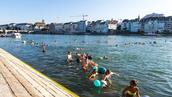
Is Your City Swimmable?
An interview with organizers of the inaugural Swimmable Cities Summit, which took place this June 22-24 in Rotterdam, NL.
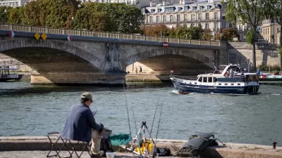
River Seine ‘Teeming’ With Life
Decades of restoration efforts are yielding positive results as dozens of species of fish return to the once-polluted waterway.
Snohomish River Gains Legal Rights
A new law in one Washington town enshrines the river’s legal right to “exist, regenerate, and flourish.”

Planetizen Federal Action Tracker
A weekly monitor of how Trump’s orders and actions are impacting planners and planning in America.

Restaurant Patios Were a Pandemic Win — Why Were They so Hard to Keep?
Social distancing requirements and changes in travel patterns prompted cities to pilot new uses for street and sidewalk space. Then it got complicated.

Map: Where Senate Republicans Want to Sell Your Public Lands
For public land advocates, the Senate Republicans’ proposal to sell millions of acres of public land in the West is “the biggest fight of their careers.”

Maui's Vacation Rental Debate Turns Ugly
Verbal attacks, misinformation campaigns and fistfights plague a high-stakes debate to convert thousands of vacation rentals into long-term housing.

San Francisco Suspends Traffic Calming Amidst Record Deaths
Citing “a challenging fiscal landscape,” the city will cease the program on the heels of 42 traffic deaths, including 24 pedestrians.

California Homeless Arrests, Citations Spike After Ruling
An investigation reveals that anti-homeless actions increased up to 500% after Grants Pass v. Johnson — even in cities claiming no policy change.
Urban Design for Planners 1: Software Tools
This six-course series explores essential urban design concepts using open source software and equips planners with the tools they need to participate fully in the urban design process.
Planning for Universal Design
Learn the tools for implementing Universal Design in planning regulations.
Heyer Gruel & Associates PA
JM Goldson LLC
Custer County Colorado
City of Camden Redevelopment Agency
City of Astoria
Transportation Research & Education Center (TREC) at Portland State University
Camden Redevelopment Agency
City of Claremont
Municipality of Princeton (NJ)