


Single-family detached homes typically epitomize sprawl, while 4 or 5 story apartment buildings now seem to be the utopian ideal for livable neighborhoods. But some of the most livable and walkable neighborhoods I know are largely comprised of single family homes.
Single-family detached homes typically epitomize sprawl, while 4 or 5 story apartment buildings now seem to be the utopian ideal for livable neighborhoods. But some of the most livable and walkable neighborhoods I know are largely comprised of single family homes.
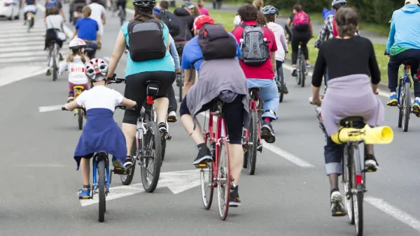
This is sprawl?
 University Heights, San Diego, CA
This is an early 20th-Century streetcar suburb lined with craftsman homes (many of which have in-law units in back) interspersed with row houses and smaller apartment buildings. Located within blocks of traditional business districts, the neighborhood has well-maintained sidewalks and service alleyways throughout. University Heights and the surrounding neighborhoods are urban in character, with multi-story dwellings clustered closer to commercial streets. Motor vehicle traffic is typically quite low; pedestrians and bicyclists abound. Open space could be better, though the neighborhood has its own park and is only a mile from Balboa Park - a large urban park.
There is an overall feeling of serenity and adequate breathing space.
This type of residential arrangement is seen in small cities and towns throughout the country, as well as the first-ring suburbs of many metropolitan areas. Transit is often a missing link in these older areas; in most cases, rail and streetcars are long gone.
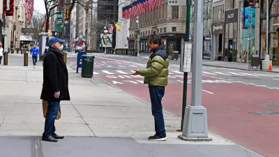
But this is not sprawl?
Fenton Parkway, San Diego, CA
This is the sort of cookie cutter housing that is popping up all over Southern California. It is high-density, autocentric suburban. Although these subdivisions are placed near transit and shopping (i.e., malls), many are logistically disconnected from these services. Car density seems to be at least as high as housing density. Functional park space and public open space are near zero, as much of the land is designated for housing and car storage.
The feeling is congested and claustrophobic.
Many of the problems associated with neighborhood #2 stem from its car-oriented framework and a serious lack of park space. If people are going to live in stacked apartments, sufficient space for outdoor recreation is essential, as is a safe framework for walking and biking.
In my experience, authentic neighborhoods like University Heights are some of the most walkable in the country, although inadequate foot traffic at night can be a safety concern on purely residential streets. Even without rail, these areas provide access and mobility because they are both centrally-located and designed for pedestrians.
So, which neighborhood density is the most livable? At what point is quality of life reduced due to overcrowding? Or does it all come down to good neighborhood design?

Unleashing the Power of Cycling With Smart Messaging
Lloyd Alter describes how creative design and copywriting can flip the script and promote active transport.
New Density Control Measure to Close Some New York Streets to Cars
To encourage recreational walking while practicing social distancing in order to reduce the spread of COVID-19, Gov. Andrew Cuomo asked the New York City mayor and city council speaker to devise a pilot project to provide for open streets.

Active Transport (Walking and Cycling) Planning for Equity
A new FHWA report, "Pursuing Equity in Pedestrian and Bicycle Planning" identifies practical ways to achieve social equity by better responding to the active travel needs of currently underserved populations.

Planetizen Federal Action Tracker
A weekly monitor of how Trump’s orders and actions are impacting planners and planning in America.

Maui's Vacation Rental Debate Turns Ugly
Verbal attacks, misinformation campaigns and fistfights plague a high-stakes debate to convert thousands of vacation rentals into long-term housing.

San Francisco Suspends Traffic Calming Amidst Record Deaths
Citing “a challenging fiscal landscape,” the city will cease the program on the heels of 42 traffic deaths, including 24 pedestrians.

Amtrak Rolls Out New Orleans to Alabama “Mardi Gras” Train
The new service will operate morning and evening departures between Mobile and New Orleans.

The Subversive Car-Free Guide to Trump's Great American Road Trip
Car-free ways to access Chicagoland’s best tourist attractions.

San Antonio and Austin are Fusing Into one Massive Megaregion
The region spanning the two central Texas cities is growing fast, posing challenges for local infrastructure and water supplies.
Urban Design for Planners 1: Software Tools
This six-course series explores essential urban design concepts using open source software and equips planners with the tools they need to participate fully in the urban design process.
Planning for Universal Design
Learn the tools for implementing Universal Design in planning regulations.
Heyer Gruel & Associates PA
JM Goldson LLC
Custer County Colorado
City of Camden Redevelopment Agency
City of Astoria
Transportation Research & Education Center (TREC) at Portland State University
Jefferson Parish Government
Camden Redevelopment Agency
City of Claremont